 Safekipedia
European exploration of Australia
Adapted from Wikipedia · Adventurer experience
The European exploration of Australia began in February 1606 when Dutch navigator Willem Janszoon landed on the Cape York Peninsula. Later that year, Spanish explorer Luís Vaz de Torres sailed through the Torres Strait islands. Many Dutch sailors came after him, exploring the western and southern coasts and naming the land New Holland.
More European explorers came later. In 1770, Lieutenant James Cook mapped the east coast for Great Britain. After Cook died, Joseph Banks suggested bringing people to live in Botany Bay in what is now New South Wales. In January 1788, a group of British ships called the First Fleet arrived at Botany Bay to start a settlement, the first on the Australian mainland. Over the next hundred years, the British made more settlements across the continent, and European explorers traveled into areas far from the coast.
Earliest European explorations
Main article: European maritime exploration of Australia
In 1606, Dutch explorers made the first European landings on Australia. The ship Duyfken, led by Willem Janszoon, reached the coast of Cape York Peninsula and met with Aboriginal people. During the 1600s, Dutch sailors charted the western and northern coasts of Australia and named the land “New Holland.” They did not try to settle there.
Dutch explorers were traveling to the Dutch East Indies for trade. They helped Europe learn more about Australia’s coast. One explorer, Dirk Hartog, landed on an island near Shark Bay. Another ship, the Leeuwin, was the first to sail around the southwestern corner of the continent. In 1642, Abel Tasman reached Van Diemen’s Land (now Tasmania) and New Zealand. His travels added to maps of Australia’s northern coast.
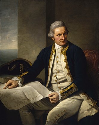
In 1770, James Cook sailed along and mapped the east coast. He named it New South Wales and claimed it for Great Britain.
Colonisation
Main article: History of Australia (1788–1850)
After losing colonies in America, the British sent ships called the "First Fleet" to start a new home in New South Wales. On 26 January 1788, they made a camp at Sydney Cove, Port Jackson. This day is now Australia Day. The leader, Captain Arthur Phillip, looked for better places to grow food and chose the Parramatta area.
Seventeen years after James Cook visited the east coast, Britain decided to create a colony at Botany Bay. After a war, Britain needed new places to live. A scientist named Sir Joseph Banks, who travelled with Cook, suggested Botany Bay as a good spot. Another explorer, Georg Forster, thought this new land, called "New Holland," would become important.
Britain claimed a large part of Australia and many islands in the Pacific Ocean. They started more settlements, including in Van Diemen's Land (now Tasmania) in 1803, and later created separate colonies like South Australia, Victoria, and Queensland. Some of these new colonies were started without using people sent there as punishment, while others did use them for a time.
Exploration of the continent
Main article: European land exploration of Australia
Early days
In 1798–99 George Bass and Matthew Flinders sailed around Tasmania, showing it was an island. In 1801–02, Matthew Flinders sailed all around Australia on the ship HMS Investigator. An Aboriginal explorer named Bungaree was on the ship. He was the first person born in Australia to sail all around the country. Before this, two men from New South Wales sailed to England with a governor in 1792.
In 1813, three men crossed the Blue Mountains west of Sydney and found wide grasslands that could support many animals. This opened up the land for British settlement.
1820s–1830s
In 1824, two men were sent to find new farmland in the south and to learn where rivers in New South Wales flowed. They traveled to Port Phillip and back, discovering the Murray River and many good places for farming.
Another explorer followed rivers in 1828 and reached the Darling River. He later followed another river to where it met the sea in South Australia. His group faced hard times and had to row back a long way.
A surveyor general led many trips in the 1830s, working with Indigenous guides. Because of this, many places still have their original Aboriginal names.
In 1836, people from South Australia started a settlement on Kangaroo Island. A Polish scientist climbed Australia’s highest mountain in 1839 and named it Mount Kosciuszko.
Other British settlements were started around the coast, but some were not successful. One settlement was started on an island in 1824, and another on the west coast in 1829.
Into the interior
Explorers traveled into Australia’s interior in the 1800s, sometimes facing big challenges. Some wanted to discover new lands for farming, while others wanted to answer scientific questions. These trips ranged from small groups to large teams with many supplies and helpers, including Indigenous guides.
From 1858, camels and the people who cared for them helped open up remote areas.
In 1860, an expedition crossed Australia from south to north, but the leaders died on the way back. In 1862, another explorer successfully crossed Central Australia, mapping a route that was later used for a telegraph line.
In 1872, Europeans first mapped Uluru and Kata Tjuta during trips made possible by the new telegraph line. One explorer called Kata Tjuta “Mount Olga,” and another called Uluru “Ayers Rock,” but these places later became valued as important symbols of Australia.
Images
Related articles


This article is a child-friendly adaptation of the Wikipedia article on European exploration of Australia, available under CC BY-SA 4.0.
Images from Wikimedia Commons. Tap any image to view credits and license.