 Safekipedia
Wiltshire
Adapted from Wikipedia · Adventurer experience
Wiltshire, often called Wilts for short, is a county in South West England. It borders Gloucestershire, Oxfordshire, Berkshire, Hampshire, Dorset, and Somerset. The largest town is Swindon, with Salisbury being an important city in the south-east. Other notable towns include Trowbridge and Chippenham.
The county covers about 3,485 square kilometers and has many people living there. Much of Wiltshire is rural, with open spaces and gentle hills. The landscape includes areas of chalk downlands, such as the Marlborough Downs and Salisbury Plain, as well as parts of the limestone Cotswolds.
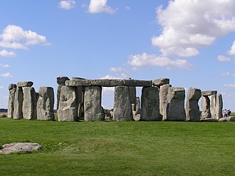
Wiltshire is famous for its ancient landmarks. Stonehenge and the stone circle at Avebury are located on Salisbury Plain and together form a UNESCO World Heritage Site. The area also has many historic sites, including Salisbury’s medieval cathedral and grand country houses like Longleat, which has a safari park. The British Army uses parts of Salisbury Plain for training.
Toponymy
The county used to be called Wiltunscir a long time ago. It is named after its old main town, Wilton.
History
Main article: History of Wiltshire
Wiltshire has a rich history, with people living there since ancient times. Famous places like Stonehenge and Avebury were built long ago, showing how people lived in the Neolithic period. Over time, Wiltshire saw many important events, including battles and changes in how the land was used.
During the 17th century, Wiltshire was mostly on the side of Parliament during the English Civil War. Later, groups were formed to protect the area, and canals were built to help move goods. Today, you can learn more about the history of Wiltshire’s many communities online. There is also a fun local story about people cleverly hiding things, which gives Wiltshire people the nickname “Moonrakers.”
Geography
See also: List of hills of Wiltshire and List of rivers of Wiltshire
Wiltshire is a quiet county where much of the land is made of chalk, a soft white rock that forms rolling hills. The biggest chalk area is Salisbury Plain, used for farming and by the British Army for training. The highest point in Wiltshire is the Tan Hill–Milk Hill ridge, standing at 295 meters above sea level.
Wiltshire also has areas made of different rocks, like limestone in the north-west and clay valleys. The county has a mild climate with warm summers and cool winters. Rain comes mostly from the west, and the county gets about 800 mm of rain each year. There is also a green belt along the western edge to help stop towns from spreading out too much.
Climate
Along with the rest of South West England, Wiltshire has a mild climate. The average temperature is about 10 °C (50 °F). July and August are the warmest months, with temperatures around 22 °C (72 °F). Winter temperatures often drop to about 1 °C (34 °F), and frost is common. The county gets less sunshine than areas closer to the sea, with about 1,600 hours of sunshine each year.
Rain in Wiltshire is often brought by weather from the Atlantic Ocean. Autumn and winter are the rainiest seasons, but any month can be wet or dry. In summer, warm ground can cause showers, especially in the north. The south of Wiltshire, closer to the English Channel, often gets less rain in summer but more in winter. On average, Wiltshire receives about 800 mm (31 inches) of rain each year. Snow falls about 8 to 15 days a year, mostly between November and March. Winds are strongest in winter and lightest in summer, usually coming from the south-west.
Green belt
Main article: Avon Green Belt
Wiltshire has a green belt mainly along its western edge, which is part of the larger Avon Green Belt. This green belt helps stop towns from growing too quickly, especially around places like Trowbridge. It also protects villages and towns near Bath in Somerset.
Demographics
Wiltshire's population has changed over time. Historically, most people in Wiltshire were from the White British group. In the 2021 census, about 85% of the people were White British.
In 2021, Wiltshire's population included many groups: 90% were White, 5% Asian, 2% Mixed, and smaller groups of Black, and other groups.
When it comes to religion, the 2021 census showed that about half of people in Wiltshire were Christian, while many had no religion, and smaller groups included Muslims, Hindus, Buddhists, Sikhs, and Jews.
| Ethnic Group | 2001 Census | 2011 Census | 2021 Census |
|---|---|---|---|
| White | 97.6% | 94.5% | 90.3% |
| Asian | 1.1% | 2.9% | 5.1% |
| Black | 0.4% | 0.9% | 1.6% |
| Mixed | 0.8% | 1.4% | 2.0% |
| Other | 0.2% | 0.3% | 0.9% |
| Religion | 2001 Census | 2011 Census | 2021 Census |
|---|---|---|---|
| Christian | 74.7% | 62.0% | 49.0% |
| No religion | 16.2% | 27.9% | 41.0% |
| Muslim | 0.5% | 0.8% | 1.3% |
| Hindu | 0.2% | 0.6% | 1.1% |
| Buddhist | 0.2% | 0.4% | 0.6% |
| Sikh | 0.2% | 0.2% | 0.3% |
| Jewish | 0.1% | 0.1% | 0.1% |
| Other religion | 0.3% | 0.5% | 0.6% |
| Not stated | 7.5% | 7.4% | 5.9% |
Governance
Wiltshire has two main local government areas: Wiltshire and Swindon. Each has its own council.
Since May 2025, Wiltshire Council has been led by Liberal Democrat leaders. In Swindon, since May 2023, the council has been led by Labour leaders.
Main article: List of parliamentary constituencies in Wiltshire
Wiltshire has eight areas that elect representatives to the UK Parliament.
In a big vote in 2016, most people in Wiltshire chose to leave a group of countries called the European Union.
| Choice | Wiltshire (ceremonial county) | Wiltshire (unitary authority) | Swindon (unitary authority) | |||
|---|---|---|---|---|---|---|
| Votes | % | Votes | % | Votes | % | |
| Leave | 213,382 | 53.1% | 151,637 | 52.5% | 61,745 | 54.7% |
| Remain | 188,478 | 46.9% | 137,258 | 47.5% | 51,220 | 45.3% |
Economy
Main article: Economy of Wiltshire
Wiltshire's economy is strong because it is close to major roads and has beautiful countryside. Big companies like Intel, Motorola, and Dyson have offices in Swindon and nearby Malmesbury. The county makes many things, such as electronics, food, furniture, and medicines.
Wiltshire also has jobs in government and the military. There are large army bases and training centers near Amesbury and Corsham. Many people in Wiltshire have jobs, and there is less unemployment here than in other places.
| Year | Regional gross value added | Agriculture | Industry | Services |
|---|---|---|---|---|
| 1995 | 4,354 | 217 | 1,393 | 2,743 |
| 2000 | 5,362 | 148 | 1,566 | 3,647 |
| 2003 | 6,463 | 164 | 1,548 | 4,751 |
Education
See also: List of schools in Wiltshire
Wiltshire has 30 public secondary schools, with the largest being Warminster Kingdown. There are also eleven private schools, such as Marlborough College, St Mary's Calne, Dauntsey's near Devizes, and Warminster School. Most of these schools are comprehensive, but Salisbury still has two special schools called grammar schools, South Wilts Grammar School and Bishop Wordsworth's School, along with three other schools that are not selective.
There are four colleges for older students, including New College in Swindon, Wiltshire College in Chippenham, Trowbridge, and Salisbury, Salisbury Sixth Form College, and Swindon College. Wiltshire also has a special school focusing on engineering called UTC Swindon.
Wiltshire is one of the few areas in England without its own university. The nearest university is the University of Bath. However, Bath Spa University has a center in Corsham, and Oxford Brookes University has a small campus in Swindon.
Service Children's Education is based in Upavon, Wiltshire.
Sport
Wiltshire has many sports teams. The main football team is Swindon Town, and they play at the County Ground stadium.
There is also a cricket club called Wiltshire County Cricket Club. In ice hockey, the Swindon Wildcats play at the Link Centre. The speedway team, Swindon Robins, stopped racing a few years ago.
Flags
Main article: Flag of Wiltshire
Wiltshire Council chose a special flag called the ‘Bustard Flag’ on December 1, 2009. The flag has eight wavy lines that change from green to white. These lines show the green fields and chalk hills of Wiltshire. In the middle of the flag is a picture of a great bustard bird. This bird was brought back to the area. The bird is shown on a green circle, and the edges of the circle have small sections in green and white. These sections stand for old stone circles like Stonehenge and nearby counties.
The great bustard bird was not seen in England since 1832. Thanks to a charity called the Great Bustard Group, birds were brought from Russia and Spain and released in Wiltshire. By autumn 2024, there were about 70 great bustards living in south Wiltshire. Some people think the flag’s design is too complicated to see clearly when it is flying.
Notable settlements
See also: List of settlements in Wiltshire by population
Wiltshire has twenty-one towns and one city. Well-known places include Amesbury, Calne, Chippenham, Corsham, Devizes, Marlborough, Melksham, Salisbury (the city), Swindon, and Trowbridge.
Media
Wiltshire’s television comes from BBC West and ITV West Country. But Swindon and Salisbury watch BBC South and ITV Meridian.
Local radio stations are BBC Radio Wiltshire, Heart West, Greatest Hits Radio South West, and Greatest Hits Radio Salisbury. The last one serves Salisbury and nearby areas.
Newspapers for the whole county are the Gazette and Herald and Wiltshire Times.
Places of interest
Wiltshire has many special places to visit. You can see Avebury, a big stone circle from long ago, and Stonehenge, one of the world’s most famous stone structures. You can also visit Lacock village, owned by the National Trust, and Longleat Safari Park to see animals.
The county has lovely natural areas, such as Salisbury Plain and the Vale of Pewsey, great for exploring the countryside.
Transport
Wiltshire has many roads, including old paths like The Ridgeway and Roman roads such as the Fosse Way, London to Bath road, and Ermin Way. You can ride bikes on National Cycle Route 4 or walk along the Thames Path, a long trail.
Important roads in Wiltshire are the A4 road, M4 motorway, A303, A350 road, and A417 road. The River Thames and the Kennet and Avon Canal are waterways you can travel on.
Three main train lines go through Wiltshire, including the Great Western Main Line, the Wessex Main Line, and the West of England line. Big train stations are at Salisbury and Westbury, with other stations at Swindon, Chippenham, and Trowbridge.
There are small airports and airfields nearby, such as Old Sarum Airfield and Clench Common Airfield. Larger airports close to Wiltshire include Bournemouth Airport, Bristol Airport, Cardiff Airport, Exeter Airport, Gloucestershire Airport, Oxford Airport, Heathrow Airport, and Southampton Airport.
Images
Related articles



This article is a child-friendly adaptation of the Wikipedia article on Wiltshire, available under CC BY-SA 4.0.
Images from Wikimedia Commons. Tap any image to view credits and license.