 Safekipedia
Lajat
Adapted from Wikipedia · Discoverer experience
The Lajat (Arabic: اللجاة/ALA-LC: al-Lajāʾ), also spelled Lejat, Lajah, el-Leja or Laja, is the largest lava field in southern Syria, covering about 900 square kilometers. It lies around 50 kilometers southeast of Damascus, bordering the Hauran plain to the west and the foothills of Jabal al-Druze to the south. The land is mostly dry and barren, with little rain each year, though some low areas can still grow crops.
Known by many names throughout history, the Lajat was called "Argob" in the Hebrew Bible and "Trachonitis" by the Greeks, a name mentioned in the Gospel of Luke. Long home to Arab groups, the area grew under the Romans, who built roads linking it to their province of Syria. Even after the Byzantine era brought many new buildings, the land saw changes over time.
During the Mongol invasions in the 13th century, people fleeing from other parts of Syria found safety here, giving the region its modern name, al-Lajāʾ, meaning "the refuge." Over the centuries, different groups lived there, including Bedouin tribes and Druze migrants from Mount Lebanon. Today, the Lajat is home to a mix of people, with Druze in the central and eastern parts, and Muslims and Melkite Christians in villages along the western edge.
Etymology
Lajat was known in ancient times as "Trachonitis," a name that means "the land of rough stones." This name was used by the Greeks for two rocky areas near Damascus. The area near Jabal al-Druze is called el-Leja in Arabic, which means "the refuge" or "asylum."
Geography
The Lajat is located in southeastern Syria. It covers a triangular area between the towns of Izra' and Shahba, stretching about 48 kilometers north to near Burraq. It is roughly 50 kilometers south of Damascus. The Lajat’s northern edge is marked by the Wadi al-Ajam gorge, separating it from the Ghouta area around Damascus. To the east lies Ard al-Bathaniyya, to the southeast is Jabal al-Druze, to the south is the Nuqrah part of the Hauran plain, and to the northwest is Jaydur, another part of the Hauran plain.
The Lajat sits at an average height of between 600 and 700 meters above sea level, higher than the surrounding flat lands. Many of its volcanic hills rise above 1,000 meters, with the tallest one, just west of Shahba, reaching 1,159 meters. The land is mostly covered in gray, broken lava fields forming sharp basalt rocks, with some smoother, rocky areas dotted with holes from gas bubbles in cooled lava. There are also round dips in the ground, called ka′ in Arabic, which are likely from past volcanic activity and provide some of the few spots where plants can grow. The area has few dry stream beds and even fewer deep cracks that can form caves or water stores.
Water is hard to find in the Lajat, with only a few natural springs and underground sources. Most villages rely on rainwater stored in cisterns, especially important during the dry summer months. In the past, people stored water in reservoirs near their homes, but by the early 1900s, these had fallen apart, so cisterns became the main way to save water.
History
Antiquity
Early history
Long ago, the area known as Trachonitis included the Lajat and the Tulul as-Safa to its east. For much of the first and second millennium BC, this area was not very important politically. It was influenced by people from Damascus, called the Arameans, and the Israelites. Later, the Seleucid Empire took control in the second century BC. During this time, Trachonitis was a border area between two groups of people: the southern Nabataeans and the northwestern Itureans, both Arab groups.
Roman period
In 24 BC, the Roman Empire took over Syria and gave the Trachonitis region, which had people who moved around and raised cattle, to Herod the Great, the king of Judaea. The Romans helped settle some people there to keep things safe. Later, during the Roman times, many towns and villages grew up. There are old ruins and writings from that time still found in the Lajat today.
Byzantine period
After the Romans, the Byzantine Empire ruled Syria. During this time, many new settlements appeared in Trachonitis. Christianity spread to some areas, especially near the southwest edge of the Lajat, starting around the middle of the sixth century.
Middle Ages
The name “Lajah” was first used in the Middle Ages. By the early 13th century, the area still had many people and villages, possibly filled by refugees from other parts of Syria during the time of the Mongol invasions. We know about thirteen places in the Lajat that have ruins from Islamic times, mostly from the 13th century.
Ottoman period
During the early years of Ottoman rule, which started in 1517, some places in the Lajat were still lived in. But by the 17th century, most of the area was empty except for a few Christian villages on the west side.
In the late 18th and during the 19th century, people from the Druze faith moved into the Lajat, mostly from areas like Wadi al-Taym and Mount Lebanon. This happened after fights in the area in 1860. Druze families settled in many places in the Lajat.
Modern period
In the early 1900s, farming in the Lajat was mostly done in the western and southwestern parts, where the soil was good for growing wheat and barley, along with some olive, apricot, and pear trees. The Lajat became a World Biosphere reserve according to UNESCO in 2009.
Biblical references
The Lajat region has a long history dating back to ancient times. It was ruled by a leader named Og when Israeli people were exploring the area. Later, it became one of the areas managed by Solomon. In the stories from Luke, the region was called Trachonitis, meaning "the rugged region." It was also part of the area ruled by Herod Philip.
The Lajat area still shows signs of its past with many old stone buildings that remain standing today. These buildings have thick walls and strong stone doors, showing how people lived long ago.
Population
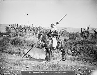
Most of the people living in the Lajat are near its edges, with only a few small villages inside. These villages are in areas without many stones. Many of these villages were built around old ruins. In the past, the Lajat was home to nomadic and semi-nomadic Bedouin tribes, farmers from the Hauran plain who sometimes stayed there, and later, Druze people from Jabal al-Druze who settled there or used it for safety and resources. The area was also a place where sheep, goats, and camels could graze.
By the early 1900s, around 5,000 semi-nomadic Bedouin from the Sulut tribe and a smaller group from the Fahsa tribe lived in the Lajat. There were also about 10,000 Druze farmers living along the eastern and southeastern edges and some in the inner parts.
| Name | District | Population (2004) | Religious makeup | Location |
|---|---|---|---|---|
| Al-Ariqah | Shahba | 3,798 | Druze | Interior |
| Asim | Izra | 821 | Muslim | Interior |
| Braykah | Shahba | 1,055 | Druze | Eastern edge |
| Burraq | As-Sanamayn | 1,799 | Druze | Interior |
| Busra al-Harir | Izra | 13,315 | Muslim | Southern edge |
| Dama | Shahba | 1,799 | Druze | Interior |
| Dhakir | Shahba | 519 | Druze | Eastern edge |
| Ad-Duwayri | As-Suwayda | 950 | Druze | Southern edge |
| Harran | Shahba | 1,523 | Druze | Interior |
| Hazm | Shahba | 858 | Druze | Eastern edge |
| Izra | Izra | 19,158 | Melkite Christian | Southern edge |
| Jaddil | Izra | 1,508 | Muslim | Interior |
| Jirrin | Shahba | 507 | Druze | Interior |
| Khabab | As-Sanamayn | 1,508 | Melkite Christian | Western edge |
| Khalkhalah | Shahba | 2,268 | Druze | Eastern edge |
| Al-Kharsah | Shahba | 547 | Druze | Interior |
| Lahithah | Shahba | 2,275 | Druze | Eastern edge |
| Lubayn | Shahba | 1,730 | Druze | Interior |
| Al-Matunah | Shahba | 1,366 | Druze | Eastern edge |
| Al-Mujaydil | Izra | 598 | ? | Western edge |
| Al-Masmiyah | As-Sanamayn | 1,498 | Melkite Christian | Interior |
| Najran | As-Suwayda | 2,955 | Druze | Southern edge |
| Qarrasa | As-Suwayda | 638 | Druze | Southern edge |
| Rimat al-Luhf | As-Suwayda | 1,925 | Druze | Southern edge |
| Rudaymat al-Liwa | Shahba | 1,001 | Druze | Eastern edge |
| Salakhid | Shahba | 950 | Druze | Interior |
| Sha'rah | As-Sanamayn | 1,508 | Muslim | Interior |
| Shahba | Shahba | 13,360 | Druze | Eastern edge |
| Sumayd | Shahba | 853 | Druze | Interior |
| Sur | Izra | 924 | Muslim | Interior |
| As-Surah al-Kabirah | Shahba | 885 | Druze | Eastern edge |
| As-Surah as-Saghirah | Shahba | 1,517 | Druze | Eastern edge |
| Umm Haratayn | Shahba | 574 | Druze | Eastern edge |
| Umm az-Zaytun | Shahba | 1,913 | Druze | Eastern edge |
| Waqm | Shahba | 429 | Druze | Interior |
Maps
Images
Related articles



This article is a child-friendly adaptation of the Wikipedia article on Lajat, available under CC BY-SA 4.0.
Images from Wikimedia Commons. Tap any image to view credits and license.