Safekipedia

Portuguese Empire

Explorer · ages 7 and underAdapted from Wikipedia
Portuguese carrack ships sailing near a rocky coastline, painted in the 1540s. Carracks were large sailing ships used by Portugal for long voyages across the oceans.

A Big Family of Lands

Long ago, Portugal had lands in many parts of the world. Together, these lands were called the Portuguese Empire. It was the first and longest-lasting of the European colonial empires, and it began during the Age of Discovery.

Sailors Find New Places

Brave Portuguese sailors began exploring the coast of Africa in 1418 and 1419. They used a special ship called the caravel. They hoped to find a sea route to the spice trade. In 1498, Vasco da Gama reached India. In 1500, Pedro Álvares Cabral reached what would later be Brazil. Sailors built stops and trading places along the way. By 1571, a chain of these stops reached all the way to Nagasaki in Japan.

Changing Times

In 1580, Portugal and Spain shared one king. Historians call this time the Iberian Union. Brazil later grew into the most valuable colony of the empire. In 1822, Brazil declared its independence and became its own country. Portugal's empire became smaller over time, but its lands still had a big effect on the world.

Today

Portugal's old empire is still remembered today. The Community of Portuguese Language Countries (CPLP) helps countries that once belonged to the empire work together on culture. Portuguese is spoken by about 240 million people. Portuguese merchants may have been the first to bring the sweet orange to Europe. Some languages even call this fruit "Portuguese" in honor of them.

Quiz time!

3 questions about Portuguese Empire

Question 1 of 3

What were all of Portugal's faraway lands called together?

Pictures

A painted folding screen from the 1600s, made in Japan, showing Portuguese traders and their companions arriving on a foreign terrace. Art like this is called Namban art, meaning 'southern barbarian' art, and it shows how Japanese artists viewed visitors from Europe.
A 17th-century map of Portugal and the Algarve, published by Nicolaes Visscher II in the 1680s and based on an earlier map by Pedro Teixeira Albernaz.
A decorative tile panel by artist Jorge Colaço, showing Prince Henry the Navigator during the conquest of Ceuta. The panel is made of painted glazed tiles called azulejos, a traditional Portuguese art form.
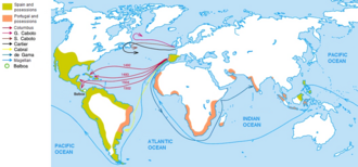
A historical map showing the lines agreed between Castile/Spain and Portugal in the 15th and 16th centuries, dividing newly discovered lands under the Treaty of Tordesillas and the Treaty of Zaragoza.
An anonymous Portuguese portrait from around 1525 showing a knight of the Order of Christ, thought to depict the explorer Vasco da Gama.
A map of Portuguese discoveries and explorations, from the 1336 claim to the Canary Islands to the arrival in Japan at Tanegashima in 1543, with the main sea routes to the Indian Ocean shown in blue.
A watercolour painting from the 16th-century Códice Casanatense shows a Portuguese nobleman in India with his attendants.
A detail from an early 1500s painting showing a Portuguese carrack, a large sailing ship called a 'nau.' The painting is part of the Retábulo de Santa Auta, kept in the National Museum of Ancient Art in Lisbon.
A hand-drawn picture of the Portuguese fortress of Diu, made by Gaspar Correia in the mid-1500s for his book Lendas da Índia.
A 16th-century Portuguese portulan, a type of old sea map used by sailors, showing parts of the coast of Africa.
A map showing the places in Morocco that were controlled by Portugal between the 1400s and 1700s.
A 16th-century portrait of Afonso de Albuquerque, a Portuguese leader who served as Viceroy of Portuguese India. The painting is kept at the National Museum of Ancient Art in Lisbon.
An old engraved harbour scene by Theodor de Bry, showing Portuguese sailing ships leaving Lisbon for the Americas in the 1500s.
1736 manuscript showing the Portuguese Navy warship Nossa Senhora da Conceição and its garrison of marines from the Terço da Armada. Considered an elite unit, Portuguese marines were recognisable by their bottle green uniforms.
Portuguese warship Rainha de Portugal saluting the squadron of Admiral Ball at Malta in 1798. In the 18th century, the Portuguese Navy was among the most powerful in the world.
The façade of St. Paul's College in Macau, 1854
The capture of Emperor Gungunhana by Mouzinho de Albuquerque at Chaimite. In the 19th century, Portugal launched campaigns to solidify Portuguese Africa, the most famous of which was the Portuguese conquest of the Gaza Empire.
Monument of the Discoveries in Lisbon
Map of the Community of Portuguese Language Countries member states associate observers officially-interested countries & territories
The Se Cathedral in Goa, India, an example of Portuguese architecture and one of Asia's largest churches

Keep exploring

This article is a child-friendly adaptation of the Wikipedia article on Portuguese Empire, available under CC BY-SA 4.0.

Images from Wikimedia Commons. Tap any image to view credits and license.