 Safekipedia
Financial District, Manhattan
Adapted from Wikipedia · Adventurer experience
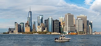
The Financial District of Lower Manhattan, often called FiDi, is a busy neighborhood at the southern tip of Manhattan in New York City. It is bordered by the West Side Highway to the west, Chambers Street and City Hall Park to the north, the Brooklyn Bridge to the northeast, the East River to the southeast, and South Ferry and the Battery to the south.
New York City was first created in what is now the Financial District back in 1624, and the area looks much like the old New Amsterdam settlement from the late 1600s. Today, it is home to many important money-related buildings, such as the New York Stock Exchange and the Federal Reserve Bank of New York. Because of Wall Street, the Financial District helps make New York City one of the most powerful money centers in the world.
The Financial District is part of Manhattan Community District 1. Its main ZIP Codes are 10004, 10005, 10006, 10007, and 10038, and it is watched over by the 1st Precinct of the New York City Police Department.
Description
The Financial District is an area in Lower Manhattan, south of City Hall Park. It does not include Battery Park or Battery Park City. It used to be home to the World Trade Center until the September 11, 2001, attacks. Today, it includes the new One World Trade Center. The center of the district is where Wall Street and Broad Street meet. In the early 1900s, part of the district along Fulton Street and John Street was called the Insurance District because many insurance companies had offices there.
Some people use "Financial District" to mean the same as Wall Street, but Wall Street often stands for the whole financial market. The Financial District is a real place and is part of Manhattan Community Board 1, which also includes Battery Park City, Civic Center, Greenwich South, Seaport, and Tribeca.
The streets here were planned before the big grid layout of Manhattan. This makes some streets very narrow, with tall buildings on each side. A few streets are for pedestrians only.
The Financial District is a popular spot for visitors. Tour guides show places like Trinity Church and the Federal Reserve Bank of New York Building, which stores gold deep underground. The New York Stock Exchange Building is also a big attraction. Tourists can see the gold vault and watch trading, which is very exciting.
Architecture
The Financial District has buildings from the Gilded Age and some art deco designs. The area has narrow streets, rolling hills, and tall buildings. It includes places like Federal Hall National Memorial, where George Washington was first sworn in as President of the United States.
Visitors can see interesting spots such as the South Street Seaport Historic District, Trinity Church, and St. Paul's Chapel. The New York Stock Exchange is an important part of the area for business and technology.
Main article: List of New York City Designated Landmarks in Manhattan, List of National Historic Landmarks in New York City, and National Register of Historic Places listings in Manhattan
Many buildings in the Financial District are recognized for their history and design. These landmarks are special because of their past or how they look. Some are noted by New York City, some by the whole country, and others are important for American history, building styles, or culture.
History
New Amsterdam
What is now the Financial District was once part of New Amsterdam, a small settlement on the southern tip of Manhattan island. It started from Fort Amsterdam, built to help the fur trade for the Dutch West India Company. In 1624, New Amsterdam became part of the Dutch Republic, and in 1625 it became the capital of New Netherland. By 1655, New Netherland had grown to 2,000 people, with 1,500 in New Amsterdam. By 1664, the population had grown to almost 9,000, with 2,500 in New Amsterdam. That year, the English took over and renamed the place New York City.
19th and 20th centuries
In the late 1800s and early 1900s, New York City became known for tall buildings called skyscrapers, along with Chicago. There were also places where people lived, like the area around Bowling Green between Broadway and the Hudson River, and between Vesey Street and the Battery. The Bowling Green area was called “Wall Street’s back yard**, but living conditions there were not good. The land in Manhattan can support tall buildings because of the strong rock underneath. Building skyscrapers was expensive, but there was little space, so tall buildings were a good idea.
A famous businessman named John Brooks wrote about this time in his book Once in Golconda. He said this was the busiest time for the Financial District. The building at 23 Wall Street, home of J. P. Morgan & Company, was called “The Corner” and was very important for business in America.
On September 16, 1920, a loud explosion happened near the corner of Wall and Broad Street, close to the Morgan Bank. Many people were hurt, and the area was worried about more trouble. In 1921, someone threatened to cause trouble again, so police blocked the streets to keep everyone safe.
Late-20th century growth
Most of the 20th century, the Financial District was mostly offices that were empty at night. But later, more people started living there. By 1970, only 833 people lived “south of Chambers Street,” but by 1990, that number grew to 13,782 as new places like Battery Park City and Southbridge Towers were built. Battery Park City was created on filled land, and by 1986, it had shops, stores, a park, and more homes being built.
Building the World Trade Center began in 1966. Even though it was hard to find companies to rent space there at first, some did. Its amazing height made it a famous landmark. Over time, the center of business in the Financial District moved from Wall Street to the World Trade Center and nearby buildings. In the late 1990s, many new projects and deals happened, including a big agreement in 1998 that kept the NYSE in New York instead of moving to Jersey City. A rival market, NASDAQ, moved its headquarters from Washington to New York.
In 1987, the stock market dropped quickly, and the following years were difficult, with many jobs lost in lower Manhattan. With lower costs for communication, banks and brokerage firms could move to cheaper places away from the Financial District. The early 1990s also brought hard times, with many office spaces left empty.
Residential neighborhood
In 1995, city leaders made a plan to help turn old office buildings into homes. Before, the area was almost empty at night, but they wanted it to feel like a real neighborhood with places to shop and live. Many old office buildings became apartments, like the Liberty Tower, which was changed into homes in 1979. By the mid-1990s, about a fifth of buildings were empty and being turned into places to live. People wanted more things like grocery stores, movie theaters, schools, and nice restaurants. By 2001, there were more shops, schools, and even a high school.
21st century
September 11 attacks
In 2001, the World Trade Center was destroyed, leaving a big empty space where new buildings had been. The attacks also caused problems with communication and lost many office spaces. Even so, the NYSE opened again just a few days later. After the attacks, barriers were put up to protect against possible car bombs, and they were made to look nicer over time.
Redevelopment
After the destruction of the World Trade Center, many new buildings were built. A new tall building called One World Trade Center opened in 2014. New train stations and transportation centers also opened to help people get around. By the 2010s, the Financial District became more like a place where people lived and worked. New tall buildings were built, and older ones were fixed up. There were also more homes, shops, and even hotels. In 2012, Hurricane Sandy caused big floods in Lower Manhattan, knocking out power and closing financial markets for a couple of days. From 2013 to 2021, many buildings in the Financial District were changed into homes, and by 2021, fewer companies in the area were in finance and insurance than before.
Demographics
The Financial District is part of a bigger area called Battery Park City-Lower Manhattan. In 2010, about 39,700 people lived there. By 2018, the number of people grew to around 61,000.
Most people here are adults between 25 and 44 years old. Many people earn good incomes, and fewer live in poverty compared to other parts of New York City. The area is considered a high-income area.
Political representation
The Financial District is part of District 1 in the New York City Council, represented by Christopher Marte.
The area is also part of the New York's 27th State Senate district and the New York State Assembly's 61st, 65th, and 66th districts. At the federal level, it is in New York's 10th congressional district, represented by Dan Goldman.
Police and crime
The Financial District and Lower Manhattan are watched over by the 1st Precinct of the NYPD. In 2010, this area was one of the safer places in the city for crime rates. Even though there are fewer crimes here than in many other parts of the city, there are also fewer people living there.
Since the 1990s, serious acts like fights and thefts have gone down a lot. In 2018, there were some cases of theft and other crimes, but the area was still safer than many other places in New York City.
Fire safety
The Financial District has three fire stations to keep everyone safe. These stations are run by the New York City Fire Department and are located at:
- Engine Company 4/Ladder Company 15/Decon Unit – 42 South Street
- Engine Company 6 – 49 Beekman Street
- Engine Company 10/Ladder Company 10 – 124 Liberty Street
Health
In 2018, the Financial District and Lower Manhattan had fewer preterm births and births to teenage mothers compared to the rest of New York City. The area also had fewer people without health insurance.
The area has more air pollution than the city average. More people here smoke than in the city overall. But rates of obesity, diabetes, and high blood pressure are lower than in the rest of the city. Most people eat fruits and vegetables every day, and many say their health is good or better. The nearest big hospital is NewYork-Presbyterian Lower Manhattan Hospital.
Post offices and ZIP Codes
The Financial District has special numbers called ZIP Codes. Some of the main ones are 10004 near the Battery, 10005 near Wall Street, 10006 near the World Trade Center, 10007 near City Hall, and 10038 near South Street Seaport. There are also a few smaller ZIP Codes, like 10045 near the Federal Reserve Bank, 10271 near the Equitable Building, and 10279 near the Woolworth Building.
The United States Postal Service has four post offices in the Financial District:
- Church Street Station – 90 Church Street
- Hanover Station – 1 Hanover Street
- Peck Slip Station – 114 John Street
- Whitehall Station – 1 Whitehall Street
Education
The Financial District and Lower Manhattan have many people with college educations. In 2018, about 84% of adults aged 25 and older had finished college. This is more than in all of Manhattan and the whole city.
Students in the area also do well in school. Math and reading scores have gone up over the years.
Fewer students miss school here than in the rest of the city. Only 6% of elementary students miss twenty or more days a year. About 96% of high school students finish on time.
The area is home to Pace University’s New York City Campus, one of the oldest universities in the city.
The New York City Department of Education runs several public schools here, including:
- Urban Assembly School of Business for Young Women (grades 9–12)
- Spruce Street School (grades PK–8)
- Millennium High School (grades 9–12)
- Leadership and Public Service High School (grades 9–12)
- Manhattan Academy for Arts and Languages (grades 9–12)
- High School of Economics and Finance (grades 9–12)
The New York Public Library has two branches nearby. The New Amsterdam branch is at 9 Murray Street. The Battery Park City branch is at 175 North End Avenue. It is the library’s first LEED-certified building.
Transportation
The Financial District in Manhattan has many subway stations. Some of these stations include Bowling Green, Broad Street, and Chambers–WTC–Park Place–Cortlandt Street.
The biggest subway station, Fulton Center, was finished in 2014. It was built to help many people travel every day. There are also buses and ferry services that stop in the Financial District, making it easy to get around.
Parks and open spaces
There is a nice place called Washington Street Plaza. It is a walking area on Washington Street between Carlisle and Albany Streets. The plaza opened in 2013.
Tallest buildings
| Name | Image | Height ft (m) | Floors | Year |
|---|---|---|---|---|
| One World Trade Center | 1,776 (541.3) | 104 | 2014 | |
| 3 World Trade Center | 1,079 (329) | 80 | 2018 | |
| 4 World Trade Center | 978 (298) | 74 | 2013 | |
| 70 Pine Street | 952 (290) | 66 | 1932 | |
| 30 Park Place | 937 (286) | 82 | 2016 | |
| 40 Wall Street | 927 (283) | 70 | 1930 | |
| 28 Liberty Street | 813 (248) | 60 | 1961 | |
| 50 West Street | 778 (237) | 63 | 2016 | |
| 200 West Street | 749 (228) | 44 | 2010 | |
| 60 Wall Street | 745 (227) | 55 | 1989 | |
| One Liberty Plaza | 743 (226) | 54 | 1973 | |
| 20 Exchange Place | 741 (226) | 57 | 1931 | |
| 200 Vesey Street | 739 (225) | 51 | 1986 | |
| HSBC Bank Building | 688 (210) | 52 | 1967 | |
| 55 Water Street | 687 (209) | 53 | 1972 | |
| 1 Wall Street | 654 (199) | 50 | 1931 | |
| 225 Liberty Street | 645 (197) | 44 | 1987 | |
| 1 New York Plaza | 640 (195) | 50 | 1969 | |
| Home Insurance Plaza | 630 (192) | 45 | 1966 | |
Many of the tallest buildings in New York City are in the Financial District. These buildings reach high into the sky and are important for the city's skyline. They hold offices and other important places for work.
Images
Related articles


This article is a child-friendly adaptation of the Wikipedia article on Financial District, Manhattan, available under CC BY-SA 4.0.
Images from Wikimedia Commons. Tap any image to view credits and license.