 Safekipedia
Highways in Poland
Adapted from Wikipedia · Adventurer experience
Highways in Poland are special roads that help people travel quickly and safely across the country. These roads are part of the national roads network and come in two types: motorways and expressways. Both types have special features like separate roads that cross over others, rest areas, and places for wildlife to cross safely.
The building of modern highways in Poland started in the 1970s, but it went very slowly at first. By 2000, only a small part of the planned highways had been built. After that, more highways were added each decade. As of March 2026, there are over 5,000 kilometers of highways open for use, with more being built.
Highways in Poland have different speed limits. On motorways, drivers can go up to 140 kilometers per hour, while on expressways the limit is 120 kilometers per hour. Some stretches of motorway require a special payment to use.
Technical parameters
Motorways in Poland are special roads just for cars. They have two lanes going each way, with a space in the middle and special areas for animals. These roads also include spots for emergencies and resting.
Expressways look similar but are built for slower driving. They can have tighter turns, narrower lanes, and sometimes only one line of traffic. They also have places to switch roads more often than motorways.
List of motorways and expressways
In 2004, Poland planned a network of highways about 7,200 kilometers long. Since then, the plan has grown to around 8,200 kilometers. This network includes 16 long highways running north to south and west to east, plus 9 shorter ones.
As of January 1, 2026, most of Poland's highways have two lanes in each direction. Some sections have three or more lanes, and a few are single-lane roads that might be widened later.
Cross-sections
Substandard highways
One older highway, A4 between Krzyżowa and Wrocław, was built a long time ago and has not been fully updated. It lacks emergency lanes and has a lower speed limit. Plans are in place to improve it soon.
| Sign | Route | Location | Total length | Existing | Years of opening | |
|---|---|---|---|---|---|---|
 | Gdańsk (S6) - Grudziądz (S5) - Toruń (S10) - Łódź (A2/S8) - Katowice Airport (S1) - Gliwice (A4) -  / / (Ostrava) (Ostrava) | 566.6 km | 566.6 km | 100% | 2007 – 2022 | |
 | Świnoujście ( / / Ystad) - Szczecin (A6) - Gorzów Wlkp. - A2 - Zielona Góra - Legnica (A4) - / (Prague) Ystad) - Szczecin (A6) - Gorzów Wlkp. - A2 - Zielona Góra - Legnica (A4) - / (Prague) | 454.9 km | 454.9 km of which 3 km near the Czech border remain closed until connecting D11 is constructed | 100% | 2010 – 2025 | |
 | / (Dresden) - Legnica (S3) - Wrocław (A8) - Opole - Gliwice (A1) - Katowice (S1) - Kraków (S7) - Rzeszów (S19) - / (Dresden) - Legnica (S3) - Wrocław (A8) - Opole - Gliwice (A1) - Katowice (S1) - Kraków (S7) - Rzeszów (S19) - / (Lviv) (Lviv) | 669 km | 669 km of which 103 km substandard: no hard shoulder | 100% | 1983 – 2016 | |
 | Łódź western bypass (S8 – A2) | Łódź | 40.2 km | 40.2 km of which 0.5 km substandard: at-grade roundabout | 100% | 2012 – 2023 |
 | / (Berlin) – Krzyżowa (A4) |  | 76.5 km | 76.5 km of which 5.6 km substandard: no hard shoulder | 100% | 2006, 2022/2023 |
 | Elbląg – /Kaliningrad Oblast |  | 52.2 km | 52.2 km single carriageway | 50% | 2008 |
 | Olsztyn (S16) – Olsztynek (S7) |  | 20.3 km | 20.3 km | 100% | 2012, 2019 |
 | Kraków northern bypass (A4 – S7) | Kraków | 18.3 km | 18.3 km | 100% | 1986 – 2024 |
 | Ostrów Mazowiecka (S8) - Łomża - Ełk (S16) - Suwałki - / (Kaunas) (Kaunas)(Via Baltica) | 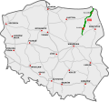 | 213.5 km | 213.5 km | 100% | 2019 – 2025 |
 | Warsaw – airport – S2 | Warsaw | 4.8 km | 4.8 km | 100% | 2013 |
 | Katowice – Sosnowiec | Upper Silesia | 5.9 km | 5.9 km | 100% | 1985 |
  2) Major completed sections | ||||||
  | Main section:/ (Berlin) - S3 - Poznań (S5/S11) - Łódź (A1/S14) - Warsaw (S7/S8/S17) | 489.7 km |  454.9 km 454.9 km 34.8 km 34.8 km | 100% | mainly 2003 – 2013 | |
 | Main section: Grudziądz (A1) - Bydgoszcz (S10) - Poznań (A2/S11) - Wrocław (A8) | 340.3 km | 340.3 km | 100% | 2012 – 2022 | |
  | Main section: Wrocław (A4) - Łódź (A1) - Piotrków T. - Warsaw (A2/S7) - Ostrów M. (S61) - Białystok (S19) | 548.2 km | 525.5 km 22.7 km | 100% | 2008 – 2019 | |
 | Main section: Warsaw (A2) – Lublin (S12/S19) | 150 km | 150 km | 100% | 2013 – 2020 | |
3) Highways under construction | ||||||||||||
|---|---|---|---|---|---|---|---|---|---|---|---|---|
| Sign | Route | Location | Total length | Existing | Construction commenced | Of which under active construction | Scheduled years of opening | Tender | In preparation | |||
 | Katowice Airport (A1) - Mysłowice (A4) - Bielsko-Biała (S52) - / (Žilina) (Žilina) | 144 km | 110.4 km + 20.7 km single carriageway | 83.9% (91%) | 12.9 km (new route) | 2026, 2027 | ||||||
| (+ 39.5 km) alternative dual-carriageway road | (100%) | |||||||||||
| Eastern section: Warsaw (S17) - Międzyrzec P. (S19) - / (Minsk) (Minsk) | 168.2 km | 72.1 km | 42.9% | 63.8 km | 2026, 2029? | 25.5 km | 6.8 km | ||||
  | / (Berlin) - Szczecin - Goleniów (S3) - Koszalin (S11) - Słupsk - Gdańsk (A1) | 412 km | 276.8 km 28.1 km | 82% | 56.3 km | 2026 | ||||||
| Szczecin western bypass | 0 km | 0% | 15.8 km | 2028, 2029, tunnel: 2032? | 35 km | |||||||
 | Gdynia - Gdańsk (A1) - Elbląg (S22) - Olsztynek (S51) - Warsaw (S8) | approx. 750 km | 352.2 km | 93.9% | 9 km (reconstruction of the 2×2 road to 2×3 highway; 2 lanes per each direction are open to traffic on the whole length of the reconstruction site) | 2027, 2032? | 13 km (reconstruction + new route) | |||||
| (+ 22 km) dual carriageway road | (100%) | |||||||||||
| Warsaw (S2) - Radom (S12) - Kielce (S74) - Kraków (A4) | 276 km + 3.4 km 1st carriageway | 98% | 2.3 km + 3.4 km 2nd carriageway | 2026 | ||||||||
| (+ 12.5 km) auxiliary route through S52 | (100%) | |||||||||||
| Kraków (A4) - Rabka-Zdrój - / (Martin) | 31.8 km | 34.6% | partial reconstruction to grade-separated (2 lanes per direction are open to traffic) | 2030?, 2032?, 2040? | approx. 60 km (new route) | |||||||
| (+ 25 km) dual carriageway road | (62%) | |||||||||||
| Southern section: Wrocław (A8) - Kłodzko - / (Brno) |  | approx. 127.4 km | 5.1 km | 4% | 68.8 km | 32 km | 2027, 2028, 2029, 2033?, 2040? | approx. 53.5 km | |||
 | Main section: Szczecin (A6) - Piła (S11) - Bydgoszcz (S5) - Toruń (A1) | 297 km | 50.2 km + 17.5 km 1st carriageway | 19.8% | 153 km + 17.5 km 2nd carriageway | 45.4 km | 2027, 2028, 2030?, 2031? | 37.8 km | 39.5 km | |||
 | Koszalin (S6) - Piła (S10) - Poznań (A2/S5) - Kępno (S8) - Piekary Śląskie (A1) | 556.5 km | 154.4 km + 10.5 km 1st carriageway | 28.7% | 122.1 km + 4.2 km 2nd carriageway | 25 km | 2026, 2028, 2029, 2031?, 2033? | 78.4 km | 36 km | |||
| + 155.1 km + 6.3 km 2nd c/w | ||||||||||||
 | Eastern section: Lublin (S17/S19) - Chełm - / (Kyiv) |  | 103.7 km | 29.2 km | 28.2% | 68.8 km | 2027, 2028, 2032? | 5.7 km | ||||
| Eastern section: Lublin (S12/S19) - Zamość - / (Lviv) |  | 126 km | 9.6 km + 2 km 1st carriageway | 8.4% | 92 km | 47.7 km | 2027, 2028, 2030?, 2nd c/w: 2032? | 22.3 km | 2 km 2nd carriageway | ||
 Via Carpatia | / (Minsk) - Białystok (S8) - Międzyrzec P. (A2) - Lublin (S12/S17) | 572.5 km | 31.2 km + 18.5 km 1st carriageway | 12.7% | 198.7 km + 18.5 km 2nd carriageway | 122.6 km + 13.7 km 2nd carriageway | 2026, 2027, 2028, 2030?, 2031? | 32 km | 37.4 km | |||
| Lublin (S12/S17) – Rzeszów (A4) | 141.7 km + 16.3 km 1st carriageway with interchanging 2+1 lanes | 94.8% (100%) | 16.3 km 2nd carriageway | 2026 | ||||||||
| Rzeszów (A4) – / (Košice) | 32.1 km | 33.2% | 64.5 km | 38.8 km | 2026, 2027, 2028 tunnels: 2028, 2030, 2031 | |||||||
 | Łódź (A1) - Sulejów (S12) - Kielce (S7) - Nisko (S19) | approx. 261 km | 16.7 km | 6.4% | 98.6 km | 18.7 km | 2027, 2028, 2032?, 2035? | 92 km | ||||
| + approx. 54 km | ||||||||||||
4) Planned highways | ||||||||||||
| Sign | Route | Location | Total length | Existing | Construction commenced | Of which under active construction | Tender | Predesign complete | In preparation | Planned completion | ||
| Eastern section: Ostróda (S7) – Grudziądz (A1) | 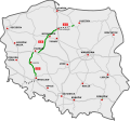 | 101.8 km | 14.3 km | 14% | 87.5 km | 2033 | |||||
| Western section: Bolków (S3) – Świdnica – S8 | 50.2 km | 0 km | 0% | 50.2 km | 2032 | |||||||
| Eastern section: Włocławek (A1) - Płock - Warsaw (S7) |  | 120.4 km | 0 km | 0% | 120.4 km | 2033 | |||||
| Western section: Piotrków Tryb. (A1) - Sulejów (S74) - Radom (S7) - Lublin (S17) | | 185 km | 16.4 km + 6.0 km 1st carriageway | 10.7% | 29.1 km | 13.2 km | 120.3 km + 6.0 km 2nd c/w | 2033 | |||
 | Olsztyn (S51) - Ełk (S61) - Białystok (S19) | 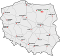 | approx. 245 km | 46.2 km + 20.1 km 1st carriageway | 23% | 19.7 km + 20.1 km 2nd carriageway | 77.5 km | 2037 | ||||
| + approx. 81.5 km | ||||||||||||
| Warsaw eastern bypass (S8 – S2) | Warsaw | 17.3 km | 3.5 km | 20.2% | 13.8 km | 2036 | |||||
  | CPK (A2) - Mińsk M. (A2) - CPK | Warsaw (2nd ring road) | approx. 265 km | 0 km | 0% | approx. 100 km approx. 165 km | 2040 | |||||
| / (Olomouc) - Cieszyn - Bielsko-Biała (S1) - Wadowice - Głogoczów (S7) | 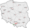 | 98 km | 37 km | 37.8% | 61 km | 2032 | |||||
In total | ||||||||||||
| Planned length | Existing | Construction commenced | Of which under active construction | Tender | Predesign complete | In preparation | No progress | |||||
| Total | approx. 8,250 km (5,126 mi) | approx. 2086 km approx. 6164 km | 5305.2 km + 149.8 km 1st carriageway | 65.21% | 1049.4 km + 62.5 km 2nd carriageway | 501.3 km + 30.4 km 2nd carriageway | 265.6 km | 0 km | approx. 1532.7 km + 14.3 km 2nd carriageway | 73 km 2nd c/w | ||
Speed limits
Other restrictions
On motorways in Poland, some vehicles like bicycles and farm vehicles are not allowed. The minimum speed on motorways is usually 40 km/h, but it can be lower in bad weather or if there is a problem with traffic. Stopping on motorways is only allowed in very special cases, and driving backwards is not permitted. Towing is not allowed on motorways, but it is allowed on expressways.
| Maximum speed (km/h) by vehicle type | Motorway | Expressway | |
|---|---|---|---|
| dual-carriageway | single-carriageway | ||
| Private car, motorbike, van up to 3.5 t (does not apply if towing trailer) | 140 | 120 | 100 |
| Bus meeting additional technical requirements | 100 | ||
| Bus; a vehicle over 3.5 t or towing trailer or carrying dangerous materials | 80 | ||
| Vehicle having equipment more than 1.5 m forward of the driver's seat | 60 | ||
| Motorbike (including towing trailer) carrying a child up to 7 years old | 40 | ||
Tolls
Since 2023, all state-owned highways are free for cars and small trucks. Some parts still have old toll equipment, but they are no longer used.
The private parts of A1, A2 and A4 highways charge a fee. These sections have special signs that say Płatna.
Vehicles over 3.5 tons and buses
Buses and bigger vehicles must use e-Toll when driving on Polish roads, not just highways. You can find more information on the e-Toll website.
| Sign | Section | Manager | Length | Price | Manual toll collection | Electronic toll collection | |
|---|---|---|---|---|---|---|---|
| Gdańsk – Toruń | GTC | 152 km | 30 PLN (€7) | Closed system: there are toll stations on every interchange; the driver receives a ticket upon entering the motorway and pays on the exit, with the price dependent on the distance driven. | Electronic toll collection through the Autopay mobile app allows one to choose the "fast gates" instead of waiting in the queue to the regular gates. | |
| Rzepin – Poznań-West | AWSA | 133 km | 50 PLN (€11) | —N/a | ||
| Poznań-East – Sługocin | 85 km | 64 PLN (€14) | Open system: two toll stations are located at the ends of the section; a person driving the whole distance pays at both gates, while a person entering or leaving the motorway mid-section pays only at one gate. | Electronic toll collection through the Autopay mobile app allows one to choose the "fast gates" instead of waiting in the queue to the regular gates. | |||
| Mysłowice – Kraków-Balice | STX | 52 km | 32 PLN (€6) | |||
Traffic volumes
Traffic on Poland's roads has grown a lot since 1989. In 2025, the average number of vehicles on national roads each day was 14,880. This is much more than in 1990. As more people use the roads, some roads became very busy. By 2010, 1,389 kilometers of roads were very busy. But after 2010, new highways opened, and the number of busy roads started to go down, from 1,389 kilometers in 2010 to 1,121 kilometers in 2020.
The most recent measurements were done in 2025. Some highways had the most traffic, while others had the least.
| Category | Section | AADT | |
|---|---|---|---|
| Busiest highways by road profile | |||
| Busiest highway with 2x5 or more lanes | S8 in Warsaw | 196,000 | |
| Busiest highway with 2x4 lanes | 163,000 | ||
| Busiest highway with 2x3 lanes | 165,000 | ||
| Busiest highway with 2x2 lanes | S6 Gdańsk bypass | 94,000 | |
| A4 Kraków western bypass | 94,000 | ||
| Busiest highway with 2+1 lanes | S19 north of Rzeszów | 24,000 | |
| Busiest highway with 1+1 lanes | S1 Żywiec bypass | 18,000 | |
| Busiest regular national roads Note: Measurements are not performed on national roads within the borders of major cities | |||
| Busiest dual-carriageway national road | DK7 north of Warsaw | 62,000 | |
| Busiest single-carriageway national road | DK44 west of Kraków | 33,000 | |
| Busiest single-carriageway national road within the planned highway network | DK74 west of Kielce | 29,000 | |
| Least busy highways | |||
| Least busy single-carriageway highway | S22 near /Kaliningrad Oblast | 1,300 | |
| Least busy dual-carriageway highway | S19 near / | 1,600 | |
| Least busy highway except near-border sections | S11 Olesno bypass | 3,500 | |
History
Before World War II
Ideas for national highways in Poland started between the world wars. Professor Melchior Wladyslaw Nestorowicz from the Warsaw University of Technology led the work. He organized three Road Congresses where experts talked about building highways. In 1939, he suggested a big plan for almost 5,000 kilometers of main roads, using ideas from Germany and Italy.
1945 – 1972
After World War II, Poland got some old highways from Nazi Germany. Many bridges were broken, and fixing them took a long time. In the years right after the war, only a few repairs were done. By the mid-1990s, most of these highways looked the same as they did in 1945.
In the 1970s
Building highways started in the 1970s. Plans included making the Gliwice-Kraków motorway and adding another road to the Wrocław-Gliwice motorway. The Warsaw-Katowice motorway, called "Gierkówka," was also planned. In the late 1970s, work on motorways began and kept going for many years.
In the 1980s
The first motorways and expressways started being built late in the 1970s and continued in the 1980s. Big roads planned as motorways were A1, A2, and A4. Other main roads were planned as expressways. But building was slow, with only about 21 kilometers of highways opened each year in the whole country during the 1980s.
In the 1990s
In modern Poland, plans for motorway S3 were changed to A3, but this was later changed back. Plans were made for motorway A8 from Łódź to Wrocław to Bolków, but these plans changed too. Parts of the Szczecin bypass (A6) and Olszyna – Krzywa (then A12, now A4/A18) were made into motorways, even though they were in bad shape.
In the 2000s
By 2000, most traffic used normal roads that went through towns. Only a few modern motorways and expressways existed, along with some old roads from Nazi Germany that had not been fixed.
Before the EU membership
Building highways went faster at the start of the 2000s. Work focused on motorways A4 and A2 going from west to east. In 2002, work began to fix the A4 from Krzywa to Wrocław, including new surfaces and bridges. In 2000, Poland started charging tolls on the A4 section between Mysłowice and Kraków.
In European Union
On May 1, 2004, Poland joined the European Union. This brought lots of money for building and improving roads. Before 2004, only Katowice and Kraków were connected by a highway. By 2005, A4 connected Wrocław with Katowice and Kraków, and by 2009, it reached Germany. In 2006, A2 connected Poznań with Łódź. Many town bypasses were built, often starting with just one road.
2011 – 2015
From 2011 to 2015, 1,563 kilometers of motorways and expressways opened. This was as much as all the roads built before. The work focused on linking Poland's biggest cities, especially those hosting UEFA Euro 2012 games, and extending A4 towards Ukraine.
2016 – 2020
After busy building before Euro 2012, not many new road contracts were signed in 2012 and 2013. So, few new road sections opened in 2015 and 2016, many delayed from the Euro 2012 plans. In 2016, the last part of A4 between Kraków and Ukraine opened, finishing A4 as Poland's first big highway. The bypass of Łódź was also finished in 2016.
Since 2014, more contracts were signed, leading to more roads opening from 2017 on.
2021 – 2025
Building highways kept going fast in the 2020s. The focus was on new highways in eastern Poland, including international routes Via Carpatia and Via Baltica.
2026 – present
The pace of building highways stays fast. Roads opening and planned for 2026 – 2030 include extending and finishing many highways, with a focus on international routes like Via Carpatia and Via Baltica.
| Signage | Section | Length | Start of construction | Opening |
|---|---|---|---|---|
 | Piotrków Trybunalski – Częstochowa substandard (multiple at-grade intersections), constructed on motorway alignment, not signed as a highway | 78 km (48 mi) | 1973 | 1976 |
| Tri-city bypass (eastern carriageway) substandard (two at-grade intersections, then reconstructed when adding a second carriageway in the 1980s) | 37.7 km (23.4 mi) | 1973 | 1977 |
| Szczecin-Rzęśnica (end of post-German A6 motorway) – Goleniów substandard (two at-grade intersections) | 19.3 km (12.0 mi) | 1976 | 1979 | |
| Total | 57 km (35.4 mi) of which 37.7 km (23.4 mi) single carriageway | |||
| Year | Length |
|---|---|
| 2011 | 313 km (194 mi) |
| 2012 | 639 km (397 mi) |
| 2013 | 298 km (185 mi) |
| 2014 | 279 km (173 mi) |
| 2015 | 34 km (21 mi) |
| Total | 1,563 km (971 mi) |
| Year | Length |
|---|---|
| 2016 | 123 km (76 mi) |
| 2017 | 295 km (183 mi) |
| 2018 | 318 km (198 mi) |
| 2019 | 410 km (255 mi) |
| 2020 | 135 km (84 mi) |
| Total | 1,281 km (796 mi) |
| Year | Length |
|---|---|
| 2021 | 375 km (233 mi) |
| 2022 | 267 km (166 mi) |
| 2023 | 245 km (152 mi) |
| 2024 | 123 km (76 mi) |
| 2025 | 268 km (167 mi) |
| Total | 1,278 km (794 mi) |
| Year | Length |
|---|---|
| 2026 | 232 km (144 mi) |
| 2027 – 2030 | 940 km (584 mi) |
| Total | 1,172 km (728 mi) |
Total length of highways by year
The length of highways in Poland has changed over time. Below is a table showing the total length of highways each year.
Images
Related articles


This article is a child-friendly adaptation of the Wikipedia article on Highways in Poland, available under CC BY-SA 4.0.
Images from Wikimedia Commons. Tap any image to view credits and license.