 Safekipedia
Geography of London
Adapted from Wikipedia · Discoverer experience
London is the largest urban area and the capital city of the United Kingdom. It is located in the southeastern part of the island of Great Britain. The London region covers 1,579 square kilometres and had a population of nearly 9 million people in 2019, making it one of the most crowded cities in the world.
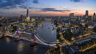
As a port on the Thames, the river has played a very important role in London's history. The city began on the north bank of the Thames, and for many years, London Bridge was the only way to cross the river. When more bridges were built in the 1700s, London grew in many directions because the land around it was mostly flat and easy to build on. Today, the Port of London continues to be a key part of the city's life and work.
360 degree panorama
A beautiful view of modern London can be seen from the Golden Gallery of Saint Paul's Cathedral. This panorama shows the city's many buildings and streets all at once, giving a sense of what life in London looks like from high above.
Rivers and canals
River Thames
The River Thames is the main river of London, flowing west to east across the London Basin. It has been shaped over time and is now protected by the Thames Barrier at Woolwich to prevent flooding. Many smaller rivers and streams also flow into the Thames, some of which are now underground.
Left bank tributaries
Larger rivers on the left side of the Thames include the Colne, Crane, Brent, Lea, Roding, Rom, and Ingrebourne. These rivers have helped shape the landscape and provided routes for travel and industry. They also supplied power for old mills and later helped London grow with factories and industries.
Right-bank tributaries
On the right side of the Thames are rivers like the Mole, Wandle, Ravensbourne, Darent, and Cray. These rivers also created paths for travel and supported mills and small industries along their valleys.
Canals
Many canals were built in London in the late 1700s and early 1800s to move goods. Today, most canals are used for leisure rather than transport. Important canals include the Regent's Canal, Grand Union, and Lee Navigation, which connect different parts of London and beyond.
Islands in the Thames
Some of the larger islands in the Thames include Chiswick Eyot, Eel Pie Island, and the Isle of Dogs, which includes Millwall and Cubitt Town.
Topography
London is located in the large bowl-shaped area called the London Basin. Most of the city sits on layers of soil and rock from a time long ago, called the Tertiary period. Only a small part of southern London, near places like Sutton, Banstead, and Croydon, rests on chalk hills that rise up from the ground.
The city is centered around the valley of the River Thames, which runs from west to east like a straight path. The river’s floodplain, where it can sometimes overflow, is about half a mile wide in the western part of London and grows to two miles wide in the east. Around this floodplain are higher, older areas of land called terraces, which stretch several miles away. Important rivers such as the Colne, Crane, Brent, Lea, Wandle, and Ravensbourne also flow towards the Thames, shaping the land around them.
London has a few small hills, but none are very tall. These hills didn’t stop the city from growing in all directions, so the city looks almost circular from above. Some of the well-known hills in central London, like Ludgate Hill, Corn Hill, and Tower Hill, may have helped decide where the very first parts of the city were built. To the north, there are higher areas of land, such as Hampstead Heath and Highgate Hill, formed from sandy soil called the Bagshot formation. South of the Thames, chalk comes closer to the surface, creating ridges like the one that includes Shooter's Hill, Greenwich Park, and Blackheath.
Climate
Main article: Climate of London
London has a temperate maritime climate, which means it has warm summers, cool winters, and moderate to strong winds. The city experiences a mix of weather throughout the year, with no very wet or very dry seasons. Because of the urban heat island effect, temperatures in central London tend to be a bit warmer than in the outer areas.
Winter daytime temperatures usually hover around 8 °C (46 °F), though they can sometimes rise to around 16 °C (61 °F) or drop as low as −7.4 °C (18.7 °F). Summer temperatures typically reach about 23 °C (73 °F), and on the warmest days, they can climb above 31 °C (88.9 °F). The city receives a good amount of sunshine, especially in the western areas, with some parts getting over 1,600 hours of sunshine each year.
Images
Related articles


This article is a child-friendly adaptation of the Wikipedia article on Geography of London, available under CC BY-SA 4.0.
Images from Wikimedia Commons. Tap any image to view credits and license.