 Safekipedia
Mississippi River
Adapted from Wikipedia · Discoverer experience
The Mississippi River is the primary river of the largest drainage basin in the United States. It is the second-longest river in the country, stretching for 2,340 miles (3,766 kilometers) from Lake Itasca in northern Minnesota to the Mississippi River Delta in the Gulf of Mexico. The river flows through or borders ten states and drains water from parts of 32 U.S. states and two Canadian provinces, making it a central feature of North America.
For thousands of years, Native Americans lived along the river, with some building large settlements and farming along its banks. When Europeans arrived in the 16th century, the river became a key route for explorers and later settlers. During the 19th century, it helped the United States expand westward and inspired many famous books, especially by Mark Twain.
Today, the Mississippi River is very important for farming, transportation, and the economy. However, it also faces serious environmental challenges, such as pollution from farms that creates a large area with little to no life in the Gulf of Mexico.
Name and significance
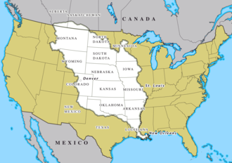
The name "Mississippi" comes from the Anishinaabe (Ojibwe or Algonquin) word Misi-ziibi, meaning "Great River." In the 1700s, the river became an important border for the new United States after the Treaty of Paris. Later, after the Louisiana Purchase, it served as a natural dividing line between the western and eastern parts of the country. Important landmarks are often described in relation to the river, like the highest peak east of the Mississippi or the oldest city west of it. The river is also known by the nickname The Mighty Mississippi River.
Main article: Gateway Arch
Main articles: Trans-Mississippi Exposition
Divisions
The Mississippi River can be divided into three sections: the Upper Mississippi, the river from its headwaters to the confluence with the Missouri River; the Middle Mississippi, which is downriver from the Missouri to the Ohio River; and the Lower Mississippi, which flows from the Ohio to the Gulf of Mexico.
The Upper Mississippi runs from its headwaters to its confluence with the Missouri River at St. Louis, Missouri. The source of the Upper Mississippi branch is traditionally accepted as Lake Itasca in Itasca State Park in Clearwater County, Minnesota. From its origin at Lake Itasca to St. Louis, Missouri, the waterway's flow is moderated by 43 dams. The Upper Mississippi has a number of natural and artificial lakes.
The Mississippi River is known as the Middle Mississippi from the Upper Mississippi River's confluence with the Missouri River at St. Louis, Missouri, for 190 miles (310 km) to its confluence with the Ohio River at Cairo, Illinois. The Middle Mississippi is relatively free-flowing.
The Mississippi River is called the Lower Mississippi River from its confluence with the Ohio River to its mouth at the Gulf of Mexico, a distance of about 1,000 miles (1,600 km). In addition to the Ohio River, the major tributaries of the Lower Mississippi River are the White River, the Arkansas River, the Big Black River in Mississippi, and the Yazoo River.
Watershed
The Mississippi River has one of the largest drainage basins in the world. Its basin covers more than 1,245,000 square miles, including parts of 32 U.S. states and two Canadian provinces. The water from this basin flows into the Gulf of Mexico, which is part of the Atlantic Ocean.
The river’s basin includes areas between the Rocky Mountains and the Appalachian Mountains. The highest point in this watershed is Mount Elbert, the tallest mountain in the Rocky Mountains, standing at 14,440 feet. The Mississippi River travels about 2,340 miles from its source to the Gulf of Mexico.
Outflow
The Mississippi River flows out at a rate of between 200 and 700 thousand cubic feet every second. It is one of the largest rivers in the world. Compared to the biggest river, the Amazon, the Mississippi has about 8% of its flow.
In the past, the river carried a lot of soil from the United States to the Gulf of Mexico. But now, it carries much less because of changes made to control the river’s flow.
Near where the river meets the Gulf of Mexico, salt water from the ocean can mix with the river’s fresh water. In dry years, this salt water can move far up the river, which can make drinking water unsafe. Special structures were built to help keep the salt water out.
The fresh water from the Mississippi does not mix right away with the ocean’s salt water. Instead, it flows into the Gulf of Mexico and even goes as far as the coast of Georgia before mixing completely.
Course changes
The Mississippi River has changed its path many times over millions of years. Long ago, when the continents were moving, a big uplift blocked water from flowing south. Later, as the land sank, the river found new ways to reach the Gulf of Mexico.
The river sometimes changes its course suddenly when it finds a shorter path. This process has moved the river's mouth many miles over thousands of years. Big changes happened after glaciers melted, shaping valleys and rivers we see today. Even in more recent history, the river has shifted, sometimes leaving towns in new places.
Length
The Mississippi River is very long. From its starting point at Lake Itasca, it is 2,340 miles (3,766 km) long. If you measure from the most distant source, which is Brower's Spring in Montana, the river becomes even longer — 3,710 miles (5,971 km). This makes it the fourth longest river in the world, after the Nile, Amazon, and Yangtze.
Depth
The Mississippi River starts very shallow at Lake Itasca, only about 3 feet deep. As it flows south, the depth changes. Near Lake Pepin, it can be up to 60 feet deep. Where the Missouri River meets the Mississippi, the depth is around 30 feet. Further down, after the Ohio River joins, the depth increases to between 50 and 100 feet. The deepest point is in New Orleans, where the river reaches an impressive 200 feet deep.
Cultural geography
State boundaries
The Mississippi River flows through or along 10 states, from Minnesota to Louisiana. It helps define parts of the borders between these states. Wisconsin, Illinois, Kentucky, Tennessee, and Mississippi lie on the east side of the river, while Iowa, Missouri, and Arkansas are on the west side. Large parts of Minnesota and Louisiana are on both sides of the river.
When the borders were set, the middle of the river was used as the boundary line. Even though the river has moved since then, the borders have stayed the same. This means some small areas of one state are now on the other side of the river.
Major communities along the river
All communities along the river
Notable towns and cities are listed from the river’s source at Lake Itasca to where it meets the Gulf of Mexico.
Bridge crossings
See also: List of crossings of the Upper Mississippi River and List of crossings of the Lower Mississippi River
The earliest bridge across the Mississippi was built in 1855 in Minneapolis, where the Hennepin Avenue Bridge stands today. The first railroad bridge was built in 1856 between Rock Island, Illinois, and Davenport, Iowa. Some famous bridges include:
- Stone Arch Bridge – A former railroad bridge now for walking in Minneapolis.
- I-35W Saint Anthony Falls Bridge – Built in 2008 after an older bridge collapsed.
- Eisenhower Bridge (Mississippi River) – Opened in 1960 in Red Wing, Minnesota.
- Eads Bridge – A famous bridge in St. Louis completed in 1874.
Many more bridges cross the river, each with its own history and design.
| Metro Area | Population |
|---|---|
| Minneapolis–Saint Paul | 3,946,533 |
| St. Louis | 2,916,447 |
| Memphis | 1,316,100 |
| New Orleans | 1,214,932 |
| Baton Rouge | 802,484 |
| Quad Cities, IA-IL | 387,630 |
| St. Cloud, MN | 189,148 |
| La Crosse, WI | 133,365 |
| Cape Girardeau–Jackson MO-IL | 96,275 |
| Dubuque, IA | 93,653 |
Navigation and flood control
Main article: List of locks and dams of the Upper Mississippi River
The Mississippi River is an important route for boats and ships. To keep it clear for travel, the United States Army Corps of Engineers works to maintain a deep water path. They started removing obstacles from the river as early as 1829.
The upper part of the river sometimes freezes in winter, but only in very cold years does the main channel freeze.
There are 29 special structures called locks and dams on the upper Mississippi. Most were built in the 1930s to keep the river deep enough for boats. These structures help create lakes that people can use for boating and fishing. They make the river wider and deeper but do not stop flooding. When the river gets too full, the gates open, and the dams stop working. Below the city of St. Louis, the river flows more freely but is guided by walls called levees and wing dams. These levees, built along both sides of the river, are very long and have sometimes been compared to the Great Wall of China.
In the lower part of the river, from Baton Rouge to where it meets the Gulf of Mexico, ships can travel because the river is deep enough. There are plans to make it even deeper so bigger ships can pass through.
19th century
In 1829, people studied two rocky parts of the river that made travel hard: the Des Moines Rapids and the Rock Island Rapids. The Des Moines Rapids were near the mouth of the Des Moines River in Iowa, and the Rock Island Rapids were between Rock Island and Moline, Illinois. Both were very difficult to pass.
In 1848, a canal was built to connect the Mississippi River to Lake Michigan through the Illinois River. This helped ships travel between these places. Later, in 1900, this canal was replaced with another that also helped keep Chicago’s water clean.
Work began in the 1830s to make the Des Moines Rapids deeper, but it took until 1877 to finish a canal around them. The Rock Island Rapids were still a problem until 1907 when a lock was built to go around them.
To help ships travel between St. Paul, Minnesota, and Prairie du Chien, Wisconsin, several dams were built on lakes near the river’s beginning. These dams stored extra water and released it when the river was low.
20th century
In 1907, plans were made to make the river deeper, but this was stopped in the late 1920s in favor of a deeper channel.
In 1913, the first dam below a major waterfall was finished at Keokuk, Iowa. It made electricity for things like streetcars in St. Louis. Another dam was finished in Minneapolis in 1917, and a third near Hastings, Minnesota was done in 1930.
Before a big flood in 1927, the strategy was to close side channels to make the main river flow faster. But the flood showed this was not safe, and some places broke their levees to reduce the flood’s power.
In the 1930s, new locks and dams were built to keep a deep channel for ships.
In the 1950s, scientists found that the Mississippi River was slowly changing its path to a different river called the Atchafalaya River. To stop this, Congress approved a project to keep the river in its current path. This project was finished in 1986.
21st century
Today, special areas are used to divert extra water during floods, protecting cities like Baton Rouge and New Orleans. Some of the old methods from before 1927 are still used, like cutting parts of the river to make the water flow faster and reduce flooding.
History
A long time ago, about 50,000 years ago, a big sea covered the central United States. The Mississippi River and its smaller rivers drained this water into the Gulf of Mexico, making new floodplains and stretching the land further south. This left very rich soil in places like Louisiana.
The area around the Mississippi River was first home to Native American peoples who hunted and gathered. It was one of the few places where people began to grow plants on purpose. They grew sunflowers, plants like goosefoot, marsh elder, and squash as early as 4,000 years ago. Over time, they began building shelters, making pottery, and weaving.
Later, between about 200 and 500 years ago, a network of trade routes called the Hopewell interaction sphere spread ideas and practices along the rivers from the Gulf of Mexico to the Great Lakes. After this, smaller communities lived in the area, and farming grew, especially with crops like corn, beans, and squash from Mesoamerica. By around 800 years ago, a society called the Mississippian culture developed, with big towns and leaders.
One of the biggest towns was Cahokia, which had between 8,000 and 40,000 people at its peak, even bigger than London at the time. When Europeans first arrived, many of these towns had broken up, and there were signs of trouble.
Europeans first reached the Mississippi River in 1519. In 1541, Spanish explorer Hernando de Soto reached the river and called it Río del Espíritu Santo. French explorers Louis Jolliet and Jacques Marquette explored the river in the 1600s. In 1682, French explorers claimed the river valley for France.
After Britain won the Seven Years' War, the Mississippi became the border between British and Spanish lands. The Treaty of Paris in 1763 gave Britain land east of the Mississippi and Spain land to the west. Later, the U.S. bought this land in the Louisiana Purchase of 1803.
Control of the river was very important during the Civil War. The Union wanted to control the river to cut off the Confederacy. They successfully took key places like Memphis, New Orleans, and Vicksburg, which helped the Union win the war.
In more recent times, the river has faced big floods, like the Great Flood of 1927 and the flood of 1993. People have built levees and other structures to control the river, but there is concern that during a very big flood, the river might change its course to a shorter path to the Gulf of Mexico.
Recreation
Water skiing began on the Mississippi River between Minnesota and Wisconsin, in a place called Lake Pepin. Ralph Samuelson from Lake City, Minnesota, invented and improved the sport in June and July 1922. He also performed the first water ski jump in 1925, pulled by a flying boat at high speed.
There are seven special places managed by the National Park Service along the Mississippi River. The Mississippi National River and Recreation Area focuses on protecting the river itself. The other six sites include Effigy Mounds National Monument, Gateway Arch National Park, Vicksburg National Military Park, Natchez National Historical Park, New Orleans Jazz National Historical Park, and Jean Lafitte National Historical Park and Preserve.
Ecology
Further information: Mississippi River System § Ecology
The Mississippi River basin is home to many different kinds of water animals and has been called the "mother fauna" of North American freshwater.
Fish
About 375 different fish live in the Mississippi basin, which is more than in many other rivers in the northern part of the world. Some special fish found here include paddlefish, sturgeon, gar, and bowfin. The Upper Mississippi River alone has around 120 fish species, such as walleye, largemouth bass, smallmouth bass, northern pike, bluegill, crappie, channel catfish, and shovelnose sturgeon.
Other fauna
The river and its surrounding areas are also home to many reptiles, including American alligators and different kinds of turtles. There are also many amphibians and crayfish. In addition, about 40% of the migratory birds in the United States use the Mississippi River during their travels in spring and fall. Even more — 60% of all migratory birds in North America — use the river basin as a path for their journeys.
Introduced species
Many animals that are not native to the area have been found in the Mississippi River. Some of these can cause problems. For example, Asian carp, including silver carp, have spread through much of the basin. They sometimes jump out of the water, which can be dangerous. The Minnesota Department of Natural Resources has noted that zebra mussels and Eurasian watermilfoil are also present in parts of the river.
Images
Related articles


This article is a child-friendly adaptation of the Wikipedia article on Mississippi River, available under CC BY-SA 4.0.
Images from Wikimedia Commons. Tap any image to view credits and license.