
Zambezi
The Zambezi (also spelled Zambeze and Zambesi) is the fourth-longest river in Africa, the longest east-flowing river in Africa and the largest flowing into the Indian Ocean from Africa. It travels through several countries, starting in Zambia and flowing through eastern Angola, along the north-eastern border of Namibia and the northern border of Botswana, then along the border between Zambia and Zimbabwe to Mozambique, where it empties into the Indian Ocean.
One of the most famous features of the Zambezi is Victoria Falls, a powerful waterfall that draws visitors from around the world. The river also has other falls, such as Chavuma Falls and Ngonye Falls.
The Zambezi plays an important role in providing energy. Two large dams, the Kariba Dam and the Cahora Bassa Dam, help create hydroelectric power for the countries it flows through. Smaller power stations at Victoria Falls and Zengamina also add to this supply.
Course
Origins
The Zambezi River starts in a marshy area in Zambia, in a place called a dambo, surrounded by special trees and plants. From there, the land around it helps separate the Zambezi from another big river called the Congo.
Upper Zambezi
From its start, the Zambezi flows southwest into Angola and then turns south. It grows wider in the rainy season and passes through different landscapes, including forests and grasslands. When it returns to Zambia, it becomes very wide and fast, with rapids and falls like the Chavuma Falls. One of its important tributaries is the Kabompo River, and the river passes through a wide floodplain area known as the Barotse Floodplain.
Middle Zambezi
After the Victoria Falls, the river flows east through a narrow gorge called the Batoka Gorge, which is exciting for kayakers and rafters. The river then fills Lake Kariba, a huge lake created by a dam, which provides power to nearby countries. Two big rivers, the Luangwa and the Kafue, join the Zambezi before it enters Mozambique.
Lower Zambezi
The lower part of the Zambezi, from a place called Cahora Bassa to the Indian Ocean, can be used for boats, though it is often shallow. The river spreads out wide in many places but narrows in the Lupata Gorge. Near the ocean, the river splits into several channels and forms a delta, with one channel, the Chinde mouth, being deep enough for ships to use.
Discharge
The section shows the average, minimum, and maximum flow of the Zambezi River at Marromeu in the lower part of the river. The data covers the years from 1998 to 2022.
| Year | Discharge (m3/s) | Year | Discharge (m3/s) | ||||
|---|---|---|---|---|---|---|---|
| Min | Mean | Max | Min | Mean | Max | ||
| 1998 | 1,141 | 3,335 | 11,183 | 2011 | 17 | 2,619 | 6,117 |
| 1999 | 600 | 4,259 | 11,084 | 2012 | 1,383 | 3,522 | 7,553 |
| 2000 | 338 | 3,041 | 6,696 | 2013 | 1,243 | 3,877 | 8,622 |
| 2001 | 112 | 9,151 | 39,802 | 2014 | 2,394 | 4,161 | 8,946 |
| 2002 | 631 | 2,536 | 4,910 | 2015 | 3,307 | 6,095 | 15,826 |
| 2003 | 329 | 2,536 | 8,952 | 2016 | 1,754 | 4,418 | 9,124 |
| 2004 | 79 | 2,013 | 4,824 | 2017 | 2,133 | 4,686 | 9,215 |
| 2005 | 888 | 3,030 | 7,973 | 2018 | 2,177 | 4,988 | 8,802 |
| 2006 | 1,549 | 3,651 | 7,575 | 2019 | 2,867 | 5,942 | 12,091 |
| 2007 | 2,208 | 4,636 | 14,141 | 2020 | 3,001 | 5,131 | 10,031 |
| 2008 | 2,881 | 6,949 | 31,975 | 2021 | 2,331 | 5,977 | 10,196 |
| 2009 | 154 | 2,648 | 5,930 | 2022 | 868 | 4,953 | 14,361 |
| 2010 | 58 | 2,284 | 6,342 | 17 | 4,217 | 39,802 | |
Delta
The Zambezi River’s delta is now about half as wide as it used to be because of dams built upstream. Before these dams, the river would flood seasonally, bringing fresh water and nutrients to the wetlands near the Indian Ocean. This flooding helped the plants and animals in the area.
After the dams were built in the 1960s and 1970s, the flooding patterns changed. Floods still happen, but they are smaller and less frequent. This has disrupted the lives of fish, birds, and other wildlife. There is also less grassland for animals and cattle to eat, and traditional ways of farming and fishing have been affected.
The delta still has many different kinds of plants and animals. It includes flooded grasslands, savannas, and forests near the water. Even with less flooding, the area remains a home for many species, including buffalo, waterbuck, reedbuck, and eland. There are also lions, leopards, cheetahs, hyenas, and jackals. The wetlands attract many birds, such as pintails, storks, and pelicans. The region is also home to reptiles like crocodiles, monitor lizards, and various snakes.
Climate
The northern part of the Zambezi river basin gets a lot of rain, about 1,100 to 1,400 millimetres each year. The amount of rain gets smaller as you move toward the southwest, where it is only about half as much. The rain comes during a summer rainy season that lasts 4 to 6 months, from October to March, when a special weather pattern moves over the area from the north. Even though there is a lot of rain, much of it disappears because of high evaporation, especially in the swamps and floodplains in the southwest.
Wildlife
The Zambezi River is home to many animals. You can find hippopotamuses in calm parts of the river, along with Nile crocodiles. There are also monitor lizards and many kinds of birds such as herons, pelicans, egrets, lesser flamingos, and African fish eagles.
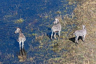
The areas near the river support large animals like buffalo, zebras, giraffes, and elephants. The river also has many fish species, including cichlids, catfish, tigerfish, and yellowfish. Some people call the bull shark the Zambezi shark, but it is different from the freshwater sharks that live in the river.
Tributaries
The Zambezi River has many smaller rivers that flow into it, called tributaries. These rivers come from different places and add their water to the Zambezi.
Some of the rivers in the upper part of the Zambezi include the Chifumage River and the Luena River from Angola, the Kabompo River from Zambia’s northwest highlands, and the Lungwebungu River also from Angola’s central plateau.
In the middle part, important rivers include the Gwayi, Sengwa, and Sanyati Rivers from Zimbabwe, as well as the Kafue River from west-central Zambia and the Copperbelt, the Luangwa River from the Luangwa Rift Valley, and the Panhane River from north-central Zimbabwe’s plateau.
In the lower part, rivers such as the Luia River, the Luenha River or Mazoe River from northeast Zimbabwe, and the Shire River from the Lake Malawi basin flow into the Zambezi.
The total area where water collects and flows into the Zambezi is very large, about 1,390,000 km2. The northern parts of this area contribute more water than the southern parts. For example, the northern highlands give about 25% of the water, while the Kafue River adds 8%, and the Luangwa and Shire Rivers each add about 16%. Together, these three areas provide most of the water. The Cuando basin in the southwest adds very little water because much of it disappears into swamps before reaching the Zambezi.
Geological history
A long time ago, more than two million years back, the upper part of the Zambezi River flowed in a different direction. It used to go south through a place now called the Makgadikgadi Pan and join the Limpopo River. This changed because the land moved and lifted up, shifting where the rivers go.
At the same time, far to the east, a smaller river in Malawi was carving out a deep valley. The middle part of the Zambezi began to shift westward very slowly. It captured other rivers flowing south, like the Luangwa and Kafue. Eventually, it reached and drained the large lake that once sat in the Makgadikgadi area. This change also affected the upper Zambezi. A big waterfall formed where the upper river met the lower part, near where Victoria Falls is today.
History
Etymology
The first European to see the Zambezi River was Vasco da Gama in 1498. He called a small nearby river Rio dos Bons Sinais or "River of Good Omens." Later, the river became known as the Cuama River. By the 16th century, people living near the river called it Zambeze. The name likely comes from a group of people who lived near a large lake far to the north.
Over time, the river was known by many names by different groups. Some called it Leeambye, meaning "large river." Others used names like Luambeji or Ambezi. In some records, it was called Kasambabezi, meaning only those who know the river can safely use it.
Exploration
For many years, maps showed the Zambezi's path based on information from Arab traders. In 1511, a Portuguese explorer named António Fernandes was the first European to travel inland near the Zambezi. He reported on trade in the area.
Famous explorer David Livingstone reached the upper Zambezi in the 1850s. He traveled down the river and discovered the powerful Victoria Falls. After that, exploration slowed for many years. Later explorers continued to study the river and its surrounding areas.
Economy
The Zambezi River Valley is home to around 32 million people. Most of them, about 80%, rely on farming, and the upper river’s floodplains offer great land for growing food.
People living near the river enjoy fishing, and many come from far away to catch fish. In some Zambian towns, unofficial fees are charged for taking fish to other parts of the country. Fishing for sport and for food is popular, and between Mongu and Livingstone, several safari lodges attract tourists who want to fish for special species and also sell fish to aquaria.
The river valley has many valuable minerals and fossil fuels, and coal mining is one important job. Dams along the river provide work for people who maintain the power stations and the dams. The river is also a popular spot for tourists. Victoria Falls welcomes over 100,000 visitors each year, with 141,929 visitors in 2015. Mana Pools and Lake Kariba also attract many visitors.
Transport
The Zambezi River has many fast-moving sections called rapids, making it hard to use for long trips by boat. A famous explorer tried to use small steam boats on the river but could not get past the big rapids.
In the 1930s and 1940s, some small boats could move between two points on the river, depending on how much water was flowing. Sometimes people helped the boats through the rapids, and other times they pulled the boats over land around the difficult spots.
Today, there are many more roads and bridges crossing the river. Some important bridges include one near Victoria Falls, which was built a long time ago in 1905, and a newer bridge opened in 2021 connecting Zambia and Botswana. There are also many small boats and ferries that help people cross the river in different places.
Ecology
The Zambezi River faces many environmental challenges. Untreated sewage from cities pollutes the water, spreading diseases and harming the river's health. Building dams has also changed the river, reducing wildlife habitats and affecting fish populations.
Efforts are being made to protect the area, including plans for a large conservation zone covering several countries. Many national parks along the river help protect its wildlife. Fish populations have declined due to overfishing, but rules like closing seasons and protecting certain areas aim to help fish recover. In 2007, a disease killed many fish, and experts studied whether it could affect people.
Major towns
The Zambezi River flows through areas where there aren't many people, but some important towns and cities are found along its path. These include Katima Mulilo in Namibia, several towns in Zambia like Livingstone, Mongu, Lukulu, Senanga, and Sesheke, as well as Victoria Falls and Kariba in Zimbabwe. In Mozambique, you can find towns such as Songo and Tete, and in Angola, there is Cazombo.
Pictures
Keep exploring



This article is a child-friendly adaptation of the Wikipedia article on Zambezi, available under CC BY-SA 4.0.
Images from Wikimedia Commons. Tap any image to view credits and license.