 Safekipedia
Four Corners
Adapted from Wikipedia · Discoverer experience
The Four Corners is a special place in the Southwestern United States. It is where four states come together: the southwestern corner of Colorado, the southeastern corner of Utah, the northeastern corner of Arizona, and the northwestern corner of New Mexico. This area is mostly home to Native American nations, with the Navajo Nation being the largest, followed by the Hopi, Ute, and Zuni peoples.
One unique spot in the Four Corners is where the borders of all four states meet at a single point, called a quadripoint. This place is marked by the Four Corners Monument, and it is the only spot in the United States where four states touch at one place.
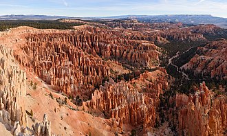
The Four Corners region is part of a bigger area known as the Colorado Plateau. It is mostly a dry, rugged landscape with many beautiful natural sites. Some popular places to visit include Monument Valley, Mesa Verde National Park, Chaco Canyon, Canyons of the Ancients National Monument, and Canyon de Chelly National Monument. The biggest city in this area is Farmington, New Mexico, with Durango, Colorado, being another important town.
Prehistory and Indigenous history
Some researchers believe that people lived in North America much earlier than many think. They use clues from old places and stories passed down to support this idea.
When Europeans first arrived, the Four Corners area was home to advanced groups like the Ancestral Puebloans. These people built homes in cliffs, created special rooms for meetings, and traded with others over long distances. Their lives were shaped by the land, their beliefs, and the way they worked together, even in a dry and tough environment.
History
The United States got the Four Corners area from Mexico after the Mexican–American War ended in 1848. In 1863, Congress made the Arizona Territory from part of the New Mexico Territory. They drew a line south from the southwest corner of the Colorado Territory, which was created in 1861. This was different because Congress usually used lines of latitude or longitude, or rivers, for boundaries.
When they made the boundary start at the corner of another, Congress made sure that four states would eventually meet at one point, even if there were mistakes in measuring. The area was first measured by the US Government in 1868 when they tried to make Colorado a state. But the original measurement was off by about 1,821 feet east of where it should have been.
In 1925, the US Supreme Court fixed this mistake by moving the Four Corners point to where the original measurement had placed it. This is where the marker stays today.
In 1923, the Navajo people set up their first tribal government to manage oil exploration on their land in the Four Corners area.
Geography
The Four Corners Monument is a special spot where four states meet. It is part of the high Colorado Plateau, which helps control weather patterns that bring rain and snow to many parts of the United States.
There are many protected areas in this region, such as Canyon de Chelly National Monument, Hovenweep National Monument, Mesa Verde National Park, and Canyons of the Ancients National Monument. The area also includes beautiful mountain ranges like the Sleeping Ute Mountains, Abajo Mountains, and the Chuska Mountains.
Politics
Six different groups share control at the Four Corners Monument: the states of Arizona, Colorado, New Mexico, and Utah, along with the tribal governments of the Navajo Nation and the Ute Mountain Ute Tribe. The Navajo Nation runs the monument through its Department of Parks and Recreation. Other tribes in the area include the Hopi and other Ute groups. The Navajo tribal government’s capital is at Window Rock in Arizona, and the Ute Mountain Ute Tribe’s headquarters are in Towaoc, Colorado. The US federal government also plays an important role, especially through groups like the Department of the Interior and the Department of Agriculture.
Cities
The Four Corners region is mostly rural, with few big cities. The main city and largest settlement there is Farmington, New Mexico. Another nearby town is Teec Nos Pos in Arizona. Other towns in the area include Cortez and Durango in Colorado; Monticello and Blanding in Utah; Kayenta and Chinle in Arizona; and Shiprock, Aztec, and Bloomfield in New Mexico.
Counties
The Four Corners region includes several counties in different states. These counties are San Juan County in New Mexico, Montezuma County in Colorado, San Juan County in Utah, and Apache County in Arizona.
Transportation
You can reach the Four Corners by air using airports in Durango, Colorado; Farmington, New Mexico; and Cortez, Colorado. Major roads like Interstate 40 and several U.S. Highways run through or near the area, including routes that lead to the Four Corners Monument.
Rail travel is also possible. A main railway line runs along the southern edge of the Four Corners, and there are special heritage railways such as the Durango and Silverton Narrow Gauge Railroad and the Cumbres and Toltec Scenic Railroad. Another railway connects a power plant to a coal mine near the region.
Helium
The Four Corners region was one of the first places in the United States where helium was found and taken out of the ground. This area is becoming more important for getting helium, especially because it has lots of high-quality helium, sometimes called 'green' helium.
The biggest helium field in this area is in Arizona, called the Holbrook Basin.
Images
Related articles




This article is a child-friendly adaptation of the Wikipedia article on Four Corners, available under CC BY-SA 4.0.
Images from Wikimedia Commons. Tap any image to view credits and license.