Greater Los Angeles
Greater Los Angeles is the most populous metropolitan area in the U.S. state of California. It covers five counties in Southern California. It stretches from Ventura County in the west to San Bernardino County and Riverside County in the east. The city of Los Angeles and Los Angeles County are at its center, and Orange County lies to the southeast. The Los Angeles–Long Beach combined statistical area (CSA) covers 33,954 square miles (87,940 km2). This makes it the largest metropolitan region in the United States by land area. Its urban area is much smaller, at 2,281 square miles (5,910 km2), because the rest of the region is mostly mountains and desert. With an estimated population of over 18.3 million (U.S. Census Bureau, 2023), it is the second-largest metropolitan area in the country, behind New York. It is also one of the largest megacities in the world.
Greater Los Angeles is the center of the global entertainment industry, which includes films, television, and recorded music. It is also an important center for international trade, education, media, business, tourism, technology, and sports. Its economy produces more than $1 trillion in output. This makes it the third-largest metropolitan area by nominal GDP in the world, behind New York City and Tokyo.
Greater Los Angeles has three connected urban areas. The first is the Inland Empire, which is broadly made up of Riverside and San Bernardino counties. The second is the Ventura/Oxnard metropolitan area in Ventura County. The third is the Los Angeles metropolitan area, also called Metropolitan Los Angeles or Metro LA, which includes only Los Angeles and Orange counties. The Census Bureau calls this area the Los Angeles–Long Beach–Anaheim metropolitan statistical area (MSA). With 13 million people as of the 2020 U.S. census, it is the fourth largest metropolitan area in the Western Hemisphere and the second-largest metropolitan area in the United States by population. It covers a total area of 4,850 square miles (12,561 km2).
San Diego–Tijuana is close to Greater Los Angeles, touching it at San Clemente and Temecula. However, it is not part of the Greater Los Angeles area. The two urban areas are not connected on land, because Camp Pendleton lies between them. Both areas are part of the Southern California megalopolis, which extends into Tijuana, Baja California, Mexico.
See also: Southern California Megalopolis
Definitions
The U.S. Office of Management and Budget defines the Los Angeles metropolitan area as the Los Angeles–Long Beach–Anaheim, CA Metropolitan Statistical Area, with a 2021 population of 12,997,353. It has two parts: Los Angeles County, California, with a 2023 population of 9,663,345, and Orange County, California, with a 2023 population of 3,135,755. It is the most populous metropolitan area in the Western United States and the second most populous in the United States. Its center is the Los Angeles–Long Beach–Anaheim urban area, which had a population of 12,237,376 in the 2020 census.
The U.S. Census Bureau also defines a wider region based on commuting patterns, the Los Angeles–Long Beach, CA Combined Statistical Area, which is more commonly known as Greater Los Angeles. Its estimated population in 2023 was 18,316,743, and its total land area is 33,955 square miles (87,945 km2). The region includes three metropolitan areas: the Los Angeles–Long Beach–Anaheim area (2023 population 12,799,100), the Oxnard–Thousand Oaks–Ventura area, which covers Ventura County (2023 population 829,590), and the Riverside–San Bernardino–Ontario, CA MSA (2023 population 4,688,053). The last one includes Riverside County, California, with 2,492,442 people, and San Bernardino County, California, with 2,195,611 people.
| Area (km2) | Population (2024) | GDP (million US$, 2024) | GDP per capita (US$) | |
|---|---|---|---|---|
| Los Angeles–Long Beach–Anaheim, CA (MSA) | 12,580 | 12,906,895 | 1,354,718 | 104,961 |
| Riverside–San Bernardino–Ontario, CA (MSA) | 70,610 | 4,747,876 | 272,671 | 57,430 |
| Oxnard–Thousand Oaks–Ventura, CA (MSA) | 4,770 | 833,431 | 69,606 | 83,517 |
| Los Angeles–Long Beach, CA CSA | 87,960 | 18,488,202 | 1,696,995 | 91,788 |
History
Main article: History of Los Angeles
Nearly all of the metropolitan area of Greater Los Angeles is located within the homelands of the Tongva, who are also called the Tovaangar.
Geography
See also: Southern California § Geology
Los Angeles has long been famous for its sprawl, mostly because it became the "poster child" of large cities that grew with suburban-style development. Today it does not rank highest for sprawl among American metro areas, since suburban and exurban-style development is now common across the country. In 2000, the Los Angeles–Orange County area was the most densely populated urbanized area in the United States, according to the United States Census Bureau, with 7,068 people per square mile (2,729/km2). The "New York–Newark" Urbanized Area had 5,309 people per square mile (2,050/km2). The city grew quickly into one of the country's ten largest cities by 1920, when suburban growth first became possible because of automobiles and electric streetcars. Its business and cultural centers were already spreading out, into edge cities such as Mid-Wilshire, Miracle Mile, and Hollywood. Freeway building from the 1950s made this growth spread even farther, so Greater Los Angeles became the earliest large American metro area with a decentralized structure. Growth continues mostly on the outer edges, where land is cheaper, and the region's droughts, wildfires, and water security have become important issues.
The traditional downtown of Greater Los Angeles is Downtown Los Angeles, but most business activity takes place in edge cities such as Century City, Wilshire Boulevard in Koreatown, Hollywood, the Sunset Strip in West Hollywood, Universal City, the Warner Center in Woodland Hills, and Sherman Oaks and Encino. Many of these areas exist alongside large suburbs. Other notable downtowns in the wider area include Downtown Long Beach, downtown Pasadena, downtown Glendale, downtown Burbank, Downtown Santa Ana, Downtown Anaheim, Downtown Riverside, Downtown San Bernardino, downtown Irvine, and downtown Ontario. Many people commute in many directions for work, and a large share travel to towns outside the city of Los Angeles. Regional identity is still disputed here, and many residents do not feel connected to the whole region. For example, South Orange County residents often try to be seen as separate from Los Angeles, even though both are in the same metropolitan area.
Component counties, subregions, and cities
Main article: Los Angeles County, California
Los Angeles County is the most populous county in the United States and is home to over a quarter of all California residents. The city of Los Angeles, the county seat, had nearly 4.1 million people at the 2020 census. It is the second most populous city in the United States after New York City. Much of the county's land is not part of any city, and it includes mountains and desert. Orange County, to the southeast, was once an agricultural area. It became a bedroom community for Los Angeles after I–5, the Santa Ana Freeway, linked it to the city in the 1950s. Today, Orange County is known for its tourist attractions and its beaches.
Main article: Orange County, California
Main article: Inland Empire (California)
The Inland Empire, made up of San Bernardino and Riverside Counties, has fast-growing suburbs, and many working people there commute to Los Angeles or Orange counties. The eastern desert parts of these counties are not considered part of Greater Los Angeles. Ventura County is mostly suburban and rural, and it has grown mainly because of Los Angeles. At the core of the Los Angeles–Long Beach combined statistical area is the Los Angeles–Long Beach–Anaheim urban area, the second most populous in the United States.
Main article: Ventura County, California
| Urban area | Population (2020 census) | Land area (sq mi) | Land area (km2) | Density (population / sq mi) | Density (population / km2) |
|---|---|---|---|---|---|
| Los Angeles–Long Beach–Anaheim, CA | 13,200,897 | 1,636.83 | 4,239.36 | 7,476.28 | 2,886.61 |
| Riverside–San Bernardino, CA † | 2,276,703 | 608.56 | 1,576.17 | 3,741.10 | 1,444.45 |
| Mission Viejo–Lake Forest–Laguna Niguel, CA | 646,843 | 163.63 | 423.81 | 3,953.02 | 1,526.27 |
| Temecula–Murrieta–Menifee, CA † | 528,991 | 150.47 | 389.73 | 3,515.49 | 1,357.34 |
| Oxnard–San Buenaventura (Ventura), CA † | 376,117 | 76.61 | 198.41 | 4,909.70 | 1,895.65 |
| Indio–Palm Desert–Palm Springs, CA † | 361,075 | 151.82 | 393.22 | 2,378.26 | 918.25 |
| Palmdale–Lancaster, CA | 359,559 | 84.78 | 219.59 | 4,240.90 | 1,637.42 |
| Victorville–Hesperia–Apple Valley, CA † | 355,816 | 131.77 | 341.29 | 2,700.19 | 1,042.55 |
| Santa Clarita, CA | 278,031 | 77.85 | 201.62 | 3,571.56 | 1,378.99 |
| Thousand Oaks, CA † | 213,986 | 80.20 | 207.71 | 2,668.26 | 1,030.22 |
| Hemet, CA † | 173,194 | 37.06 | 95.98 | 4,673.61 | 1,804.49 |
| Simi Valley, CA † | 127,364 | 31.63 | 81.91 | 4,027.01 | 1,554.84 |
| Camarillo, CA † | 76,338 | 22.48 | 58.22 | 3,395.98 | 1,311.19 |
| Desert Hot Springs, CA † | 45,767 | 14.08 | 36.47 | 3,250.66 | 1,255.09 |
| Santa Paula, CA † | 30,675 | 4.96 | 12.86 | 6,179.04 | 2,385.74 |
| Barstow, CA † | 30,522 | 12.38 | 32.07 | 2,465.05 | 951.76 |
| Crestline–Lake Arrowhead, CA † | 22,272 | 16.85 | 43.64 | 1,321.70 | 510.31 |
| Yucca Valley, CA † | 18,293 | 11.33 | 29.36 | 1,613.95 | 623.15 |
| Big Bear, CA † | 16,498 | 15.93 | 41.26 | 1,035.73 | 399.90 |
| Fillmore, CA † | 16,397 | 2.63 | 6.82 | 6,227.80 | 2,404.57 |
| Twentynine Palms, CA † | 12,881 | 6.82 | 17.66 | 1,889.13 | 729.40 |
| Blythe, CA–AZ † | 11,780 | 6.20 | 16.06 | 1,899.83 | 733.53 |
| Twentynine Palms North, CA † | 11,665 | 2.77 | 7.18 | 4,206.03 | 1,623.96 |
| Fort Irwin, CA † | 8,096 | 3.62 | 9.37 | 2,238.42 | 864.26 |
| Mecca, CA † | 6,875 | 0.63 | 1.62 | 10,979.30 | 4,239.13 |
| Needles, CA–AZ † | 6,739 | 5.55 | 14.38 | 1,213.99 | 468.73 |
| Silver Lakes, CA † | 5,908 | 2.12 | 5.49 | 2,789.52 | 1,077.04 |
| Running Springs, CA † | 5,313 | 3.64 | 9.44 | 1,458.40 | 563.09 |
| Joshua Tree, CA † | 4,370 | 3.80 | 9.85 | 1,149.11 | 443.67 |
| Wrightwood, CA † | 3,927 | 1.38 | 3.59 | 2,835.51 | 1,094.80 |
| Avalon, CA | 3,362 | 1.19 | 3.08 | 2,826.47 | 1,091.31 |
Demographics
In the 2020 census, 18,644,680 people lived in the Greater Los Angeles Area. About 29.4% were White, 13.8% were Asian, 6.1% were African American, 0.2% were Pacific Islander, 0.2% were Native American, 0.5% were from other races, and 3.3% were of two or more races. These groups are non-Hispanic. Also, 46.3% of residents were Hispanic, and most of them were of Mexican origin. About 29.4% of residents were born outside the United States, mostly in Latin America and Asia. The region grew quickly in the 20th century. Its Mediterranean climate, available land, and industries such as oil, automobile and rubber, motion pictures, intermodal, logistics, and aerospace drew millions of people. Citrus farming also helped the area grow early in the 20th century.
The New York metropolitan area is currently the largest metropolitan area in the United States. In the past, people predicted that Greater Los Angeles would one day pass it, but those predictions were wrong. A 1966 article in Time included San Diego, which is its own metropolitan area, in its count. A 1989 article in The New York Times predicted Greater Los Angeles would pass Greater New York by 2010, but New York had already passed that number by 2007. In 2009, New York had 22.2 million people and Greater Los Angeles had 18.7 million. Still, Greater Los Angeles grew by a larger percentage than Greater New York over recent decades.
According to the 2009 American Community Survey, the Los Angeles Metropolitan Area had 12,874,797 people, and about half were men and half were women. Non-Hispanic whites made up about 5.5 million residents. Their largest European ancestries were German, English, Irish, Italian, Scandinavian, French, Scottish, Polish, and Russian. The largest Middle Eastern ancestries were Jewish, Armenian, Arab, and Iranian. Asian residents numbered about 2.6 million, with South Asian people making up about 1.4%. The largest Asian ancestries were Chinese, Filipino, Vietnamese, Korean, Indian, and Japanese. Other Asian groups included Cambodian, Laotian, Hmong, Taiwanese, Pakistani, and Thai Americans. Non-Hispanic Black residents numbered about 1.1 million. The largest Pacific Islander ancestries were Samoan, Native Hawaiian, Chamorro, and Tongan. Among Hispanic or Latino residents, about 8.6 million, the largest group was Mexican, followed by Salvadoran, Guatemalan, Honduran, Peruvian, Puerto Rican, Colombian, and Cuban.
| Census | Pop. | %± | |
|---|---|---|---|
| 1900 | 250,187 | — | |
| 1910 | 648,316 | 159.1% | |
| 1920 | 1,150,252 | 77.4% | |
| 1930 | 2,597,066 | 125.8% | |
| 1940 | 3,252,720 | 25.2% | |
| 1950 | 4,934,246 | 51.7% | |
| 1960 | 7,751,616 | 57.1% | |
| 1970 | 9,981,942 | 28.8% | |
| 1980 | 11,497,486 | 15.2% | |
| 1990 | 14,531,529 | 26.4% | |
| 2000 | 16,373,645 | 12.7% | |
| 2010 | 17,877,006 | 9.2% | |
| 2020 | 18,644,680 | 4.3% | |
| 2023 (est.) | 18,316,743 | −1.8% | |
| U.S. Census Bureau | |||
| County | 2025 Estimate | 2020 Census | Change | Area | Density |
|---|---|---|---|---|---|
| Los Angeles County | 9,694,934 | 10,014,009 | −3.19% | 4,057.88 sq mi (10,509.9 km2) | 2,389/sq mi (922/km2) |
| Orange County | 3,149,507 | 3,186,989 | −1.18% | 790.57 sq mi (2,047.6 km2) | 3,984/sq mi (1,538/km2) |
| Total | 12,844,441 | 13,200,998 | −2.70% | 4,848.45 sq mi (12,557.4 km2) | 2,649/sq mi (1,023/km2) |
| Census | Pop. | %± | |
|---|---|---|---|
| 1890 | 115,043 | — | |
| 1900 | 189,994 | 65.2% | |
| 1910 | 538,567 | 183.5% | |
| 1920 | 997,830 | 85.3% | |
| 1930 | 2,327,166 | 133.2% | |
| 1940 | 2,916,403 | 25.3% | |
| 1950 | 4,367,911 | 49.8% | |
| 1960 | 6,742,696 | 54.4% | |
| 1970 | 8,462,366 | 25.5% | |
| 1980 | 9,410,130 | 11.2% | |
| 1990 | 11,273,720 | 19.8% | |
| 2000 | 12,365,627 | 9.7% | |
| 2010 | 12,828,837 | 3.7% | |
| 2020 | 13,200,998 | 2.9% | |
| 2023 (est.) | 12,799,100 | −3.0% | |
| State Census data | |||
| Age distribution Los Angeles and Orange Counties, 2009 | |
|---|---|
| Age | % of pop. |
| Under 5 | 7.3% |
| 5 to 9 | 6.6% |
| 10 to 14 | 7.0% |
| 15 to 19 | 7.2% |
| 20 to 24 | 7.0% |
| 25 to 34 | 15.5% |
| 35 to 44 | 14.8% |
| 45 to 54 | 13.9% |
| 55 to 59 | 5.5% |
| 60 to 64 | 4.4% |
| 65 to 74 | 5.6% |
| 75 to 84 | 3.6% |
| 85 and over | 1.6% |
| Median age | 34.6 |
Ethnic enclaves
Further information: List of districts and neighborhoods of Los Angeles
Many neighborhoods in Los Angeles are home to particular cultural communities. Examples include Chinatown, the Byzantine-Latino Quarter, Historic Filipinotown, Little Saigon, Little Armenia, Little Ethiopia, Little Bangladesh, Little Moscow (in Hollywood), Little Tokyo, Croatian Place and Via Italia in San Pedro, several Koreatowns, Tehrangeles in West Los Angeles, the Chinese enclaves in the San Gabriel Valley and Thai Town. These areas show how Los Angeles is polyglot (speaking many languages) and multicultural.
A list of many ethnic enclaves in the Los Angeles metropolitan area appears below.
Politics
Greater Los Angeles is politically divided. During the 1970s and 1980s, the region leaned toward the Republican Party. Los Angeles County, the most populous part of the region, is a Democratic stronghold, although it voted twice for both Richard Nixon (1968 and 1972) and Ronald Reagan (1980 and 1984).
Riverside County, San Bernardino County, and Orange County have historically leaned toward the Republican Party but have started shifting to the left in recent years. Ventura County is politically divided.
Economy
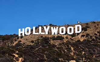
The Los Angeles metropolitan area has the third-largest economy of any metropolitan area in the world, behind the Greater Tokyo Area and the New York metropolitan area. In 2022, the combined statistical area of Greater Los Angeles, which includes the Los Angeles metropolitan area, the Inland Empire, and Ventura County, had a $1.528 trillion economy. Los Angeles and Orange Counties together have an economy of roughly $1.227 trillion. Coastal California land values and the rents they bring add a lot to the economy, but high land values may make housing hard to afford and could slow future economic growth. The Inland Empire is a large part of the region but adds much less to the gross metropolitan product, though it still leads in industry. The Greater Los Angeles area is the third-largest economic center in the world, after Greater Tokyo and the New York-Newark-Bridgeport area. Several Asian car companies have their U.S. headquarters in the area, including Mitsubishi, Hyundai, Honda, and Mazda. Nissan and Toyota were also based there in the past, but Nissan moved to Tennessee and Toyota moved to Texas. The economy is well known for its entertainment industry, especially television, motion pictures, interactive games, and recorded music. The Hollywood area and nearby places are called the "movie capital of the United States" because of their importance to the motion picture industry. Shipping and trade, logistics, aerospace, technology, petroleum, fashion, apparel, and tourism are also important. The Port of Los Angeles and Port of Long Beach together form the busiest seaport in the United States, and the Inland Empire has the largest concentration of warehouses and intermodal facilities in the world.
The City of Los Angeles once had five Fortune 500 companies: energy company Occidental Petroleum, which moved its headquarters to Houston in 2014, healthcare provider Health Net, metals distributor Reliance Steel & Aluminum, engineering firm AECOM, and real estate group CB Richard Ellis. As of 2024, all of these companies had moved elsewhere. Other companies with headquarters in Los Angeles include American Apparel, City National Bank, 20th Century Studios, Latham & Watkins, Univision, Metro Interactive, LLC, Premier America, Gibson, Dunn & Crutcher, DeviantArt, Guess?, O'Melveny & Myers, Paul, Hastings, Janofsky & Walker, Tokyopop, The Jim Henson Company, Paramount Pictures, Sunkist Growers, Incorporated, Tutor Perini, Fox Sports Net, Capital Group, and The Coffee Bean & Tea Leaf. Korean Air has its U.S. passenger and cargo operations in two offices in Los Angeles. The entertainment company The Walt Disney Company is headquartered in nearby Burbank. The Port of Los Angeles and Port of Long Beach together are the fifth-busiest port in the world and a center of trade on the west Pacific Coast, and they are among the most important ports in the Western Hemisphere. The Port of Los Angeles is the busiest container port in the United States. The Port of Long Beach, which sits next to it in the city of Long Beach, California, is the second-busiest container port in the country and serves as a major gateway for trade with Asia. It provides more than 316,000 jobs in Southern California. In 2014, the Long Beach–Los Angeles–Anaheim area had 13,262,220 people, ranking second in the United States, and its per capita personal income was $50,751, ranking 29th in the country. That year, the area ranked third among the largest exporters in the United States, with $75.5 billion in shipments.
Utilities and infrastructure
There are nine electric power companies in the Los Angeles metropolitan area. Southern California Edison serves most of the area, except Los Angeles city limits, Burbank, Glendale, Pasadena, Azusa, Vernon, Anaheim, and southern Orange County. Southern Orange County is part of the metropolitan area and is served by San Diego Gas & Electric.
There are three natural gas providers in the metropolitan area. Southern California Gas Company serves most of the area, except Long Beach and southern Orange County.
Medical facilities
Greater Los Angeles is one of the world's largest destinations for patients. The Los Angeles Medical Services provide good medical and specialty care to the people they serve, following local, state, and federal rules and protecting human rights.
Los Angeles and Orange counties have separate medical service departments, but they work together. Government and private hospitals are normally open Monday through Friday, except on city holidays, and some specialty hospitals are open all year. The main healthcare providers in the Los Angeles area are Kaiser Permanente, Cedars-Sinai Health System, UCLA Health, Dignity Healthcare, and Providence Healthcare. LA Care and Care1st are also main providers for people in the area who have Medi-Cal.
Events
See also: Category:Annual events in California and Category:Annual events in Los Angeles County, California
Major events in the area include the 626 Night Market, the BNP Paribas Open, the LA Auto Show, the Laguna Beach Pageant of the Masters, the Los Angeles Film Festival, the Newport Beach Christmas boat parade, the Palm Springs International Film Festival, the Rose Parade, the Sawdust Art Festival, the Temecula Valley Balloon & Wine Festival, and the Vans U.S. Open of Surfing.
The section also lists awards ceremonies, including the Academy Awards, the Primetime Emmy Awards, the Golden Globes, the Grammy Awards, and the Screen Actors Guild Awards.
Tourism
See also: List of museums in Los Angeles County, California
Greater Los Angeles is one of the most visited areas in the world. It is known for its mild weather, its popular beaches and amusements, its cultural centers, and its natural beauty. In 1999, a total of 23.8 million visitors stayed for at least one night.
Area and ZIP codes
Area codes
Main article: List of California area codes
Greater Los Angeles uses several area codes. Each one covers a different part of the region.
- (/wiki/Area_code_213) covers Downtown Los Angeles, which is surrounded by 323.
- 310/424 covers Santa Monica, Malibu, Pacific Palisades, Compton, Lynwood, Torrance, Beverly Hills, Catalina Island, and the southwestern part of Los Angeles County.
- (/wiki/Area_code_323) forms a ring around downtown Los Angeles. It includes the Hollywood and Eagle Rock neighborhoods of Los Angeles, South Los Angeles, the cities of South Gate, Huntington Park, Vernon, Walnut Park, Florence, Bell, Bell Gardens, Cudahy, Montebello, and East Los Angeles.
- 442/760 covers Coachella Valley, including Palm Springs and Indio, and Victor Valley, including Victorville and Apple Valley.
- (/wiki/Area_code_562) covers Long Beach, Downey, Whittier, Norwalk, Lakewood, Bellflower, Paramount, Cerritos, southeast Los Angeles County, and a small part of coastal Orange County.
- (/wiki/Area_code_626) covers Pasadena, Monterey Park, Rowland Heights, Alhambra, West Covina, the San Gabriel Valley, and eastern suburbs of Los Angeles.
- 657/714 covers Anaheim, Huntington Beach, Santa Ana, Orange, Garden Grove, and northern and western Orange County.
- 747/818 covers the cities of Burbank, Glendale, and San Fernando, the North Hollywood, Van Nuys, Panorama City, Sherman Oaks, and Northridge neighborhoods of Los Angeles, and the San Fernando Valley.
- 805/820 covers Ventura County, including the cities of Oxnard, Simi Valley, Thousand Oaks, and Ventura.
- 909/840 covers southwest San Bernardino County, a small part of Riverside County, and the far eastern Los Angeles County suburbs of Pomona, Walnut, Diamond Bar, San Dimas, La Verne, and Claremont.
- (/wiki/Area_code_949) covers Irvine, Laguna Beach, Newport Beach, San Juan Capistrano, and southern and eastern Orange County.
- (/wiki/Area_code_951) covers Corona, Hemet, Jurupa Valley, Lake Elsinore, Menifee, Moreno Valley, Riverside, Temecula, and the western end of Riverside County.
Media
Main article: Mass media in Los Angeles
The Los Angeles area is home to the headquarters of several well-known media companies, including the Los Angeles Times, Fox Broadcasting Company, Universal Studios, and The Walt Disney Company.
Many local TV channels reach the Los Angeles area, including KCBS-TV (CBS), KNBC (NBC), KTLA (The CW), KABC (ABC), KCAL-TV (Independent), KTTV (Fox), KCOP (MyNetworkTV), KCET (PBS), KPXN-TV (Ion), KMEX-DT (Univision), KVEA (Telemundo), and KLCS (PBS). Radio stations serving the area include KKJZ, KIIS, KNX (AM), and KMZT.
Education
The Los Angeles Unified School District serves the city of L.A., and other school districts serve the surrounding areas. A number of private schools are also located in the region.
Greater Los Angeles is home to a number of colleges and universities. The University of Southern California and University of California, Los Angeles are among the largest, and the Claremont Colleges and California Institute of Technology are among the most academically renowned. Below is a list of some of the best-known colleges and universities in the Los Angeles area.
- Art Center College of Design
- Azusa Pacific University
- Biola University
- California Baptist University
- California Lutheran University
- California State University, Channel Islands
- California State University, Dominguez Hills
- California State University, Fullerton
- California State University, Northridge
- California State University, Long Beach
- California State University, Los Angeles
- California State University, San Bernardino
- California State Polytechnic University, Pomona
- California Institute of Technology
- Chapman University
- Claremont Colleges
- Laguna College of Art and Design
- Loma Linda University
- Loyola Marymount University
- Otis College of Art and Design
- University of California, Irvine
- University of California, Los Angeles
- University of California, Riverside
- University of Southern California
- University of La Verne
- University of Redlands
- Pepperdine University
- Soka University of America
- Vanguard University
- West Coast University
Transportation
Greater Los Angeles is known for its large transportation network, especially its highways. It is a junction for many interstates coming from the north, east, and south, and it contains the three main north–south highways in California: Interstate 5, U.S. Route 101, and California State Route 1. The area also has several ports, including the twin ports of Long Beach and Los Angeles, which are the two busiest in the United States, and Port of Hueneme. The Los Angeles Metro Rail connects neighborhoods of Los Angeles with nearby suburbs, and Metrolink commuter rail links most of the region with Oceanside in San Diego County. Los Angeles International Airport (LAX) is the main international airport of the region and one of the busiest in the world. Other airports include Ontario International Airport (ONT), John Wayne Airport (SNA), Hollywood Burbank Airport (BUR), Long Beach Municipal Airport (LGB), and Palm Springs International Airport (PSP).
The Pacific Electric Railway Company, nicknamed the Red Cars, was a privately owned mass transit system in Southern California. It used electric streetcars, interurban cars, and buses, and in the 1920s it was the largest electric railway system in the world. It connected cities in Los Angeles, Orange, San Bernardino, and Riverside County. It shared dual gauge track with the 3 ft 6 in narrow gauge Los Angeles Railway on Main Street and Hawthorne Boulevard. LAX is in southwestern Los Angeles, about 16 miles (26 km) from Downtown, and is the only airport that serves as a hub for all three U.S. legacy airlines: American, Delta, and United. Other airports serving the region include other airports, Long Beach Airport, and San Bernardino International Airport. The area has one suspension bridge, Vincent Thomas Bridge in San Pedro, and one cable-stayed bridge, Long Beach International Gateway in Long Beach.
Main article: Southern California freeways
The freeways include the Santa Ana Freeway and I-5, I-15, I-105, I-110, I-210, I-215, I-405, I-605, and I-710. The U.S. highways include the Will Rogers Highway, formerly Route 66, the Pacific Highway, formerly US 99, the Hollywood Freeway, and US 101. The state highways include SR 19, SR 22, SR 23, SR 27, SR 33, SR 34, SR 39, SR 47, SR 55, SR 57, SR 60, SR 66, SR 72, SR 73, SR 74, SR 83, SR 90, SR 91, SR 103, SR 107, SR 110, SR 118, SR 126, SR 133, SR 134, SR 138, SR 142, SR 170, SR 187, SR 210, SR 213, SR 241, SR 261, and SR 710.
Main article: Los Angeles County Metropolitan Transportation Authority
The Los Angeles Metro Rail is the mass transit rail system of Los Angeles County. It is run by the Los Angeles County Metropolitan Transportation Authority and has six rail lines, including the A Line, B Line, C Line, D Line, E Line, G Line, J Line, and K Line. Its light rail lines are the second busiest LRT system in the United States, after Boston, and by 2019 it had become the most heavily ridden light rail system in the country. Metro also runs an extensive bus system and a microtransit service, and it funds independent transit operators such as Foothill Transit, Long Beach Transit, Santa Monica Big Blue Bus, and LADOT Transit. Other local services are provided by the Orange County Transportation Authority, the San Bernardino County Transportation Authority, and the Riverside Transit Agency.
The region's two heavy rail providers are Amtrak and Metrolink. Amtrak serves San Diego, Santa Barbara, San Luis Obispo, and places in between on the Pacific Surfliner, and it runs long-distance routes such as the Coast Starlight, the Southwest Chief, and the Sunset Limited. Metrolink serves many places across Southern California, including all counties in the region, with 67 stations on eight lines that mostly radiate from Los Angeles Union Station.
| Airport | IATA code | County | Enplanements (2013) |
|---|---|---|---|
| Los Angeles International Airport | LAX | Los Angeles | 32,425,892 |
| John Wayne Airport | SNA | Orange County | 4,540,628 |
| Ontario International Airport | ONT | San Bernardino | 1,970,538 |
| Hollywood Burbank Airport | BUR | Los Angeles | 1,918,011 |
| Long Beach Airport | LGB | Los Angeles | 1,438,756 |
| San Bernardino International Airport | SBD | San Bernardino | N/A |
| Hawthorne Municipal Airport | HHR | Los Angeles | N/A |
| Van Nuys Airport | VNY | Los Angeles | N/A |
Sports
Main article: Sports in Los Angeles
Further information: History of the NFL in Los Angeles
Professional teams
Main article: Sports in Los Angeles
The Los Angeles area has won more national championships in all sports, college and professional combined, than any other United States city. It has over four times as many as the entire state of Texas and just over twice as many as New York City. Los Angeles is the only American city to host the Summer Olympics twice, in (/wiki/1932_Summer_Olympics) and (/wiki/1984_Summer_Olympics). It will also host the 2028 Summer Olympics, becoming the third city to host three Olympic Games, after London and Paris.
Table of professional teams and venues
Other professional venues include:
- Auto Club Raceway, Pomona
- John C. Argue Swim Stadium
- Long Beach Marine Stadium
- Los Alamitos Race Course
- Los Angeles Memorial Coliseum
- Pico Rivera Sports Arena
- Rose Bowl
- Santa Anita Park
- Kia Forum
- VELO Sports Center
NCAA Division I college sports
- California Baptist Lancers
- Cal State Fullerton Titans
- Cal State Northridge Matadors
- Long Beach State Beach
- Loyola Marymount Lions
- Pepperdine Waves
- UC Irvine Anteaters
- UC Riverside Highlanders
- UCLA Bruins (FBS)
- USC Trojans (FBS)
Other sports
The Greater Los Angeles area has three well-known horse racing facilities: Santa Anita Park, Los Alamitos Race Course, and the former Hollywood Park Racetrack. It also has three major motorsport venues: Long Beach street circuit, Auto Club Raceway at Pomona, and the demolished Auto Club Speedway.
For over twenty years, the Los Angeles area had no National Football League team. After the 1994 season, the Los Angeles Rams moved to St. Louis, Missouri, and the Los Angeles Raiders returned to their original home in Oakland, California. Many stadium proposals were made between 1995 and 2016 to bring the NFL back. On January 12, 2016, the Rams were approved to move to Los Angeles and build what is now known as SoFi Stadium. On January 12, 2017, the Chargers announced they would also move to Los Angeles to join the Rams. Both teams share SoFi Stadium in Inglewood, California.
Panoramas
This photo shows Central Los Angeles and the Westside, seen from the Getty Center in the Santa Monica Mountains. The San Gabriel Mountains rise in the back on the left, and the Downtown Los Angeles skyline appears in the middle left. Century City and Westwood are in the front, with the 405 Freeway nearby. On the right are the Brentwood skyline, the hills of the Palos Verdes Peninsula, and the Pacific Ocean.
This view of the Los Angeles Basin is taken looking south from Mulholland Drive. From left to right, you can see the Santa Ana Mountains and Saddleback on the horizon, downtown L.A., the Hollywood Bowl in the front, Mid-Wilshire, and Long Beach with Palos Verdes behind it. Catalina Island appears on the horizon, followed by the South Bay and the Pacific Ocean.

Quiz time!
5 questions about Greater Los Angeles
Why is the urban area of Greater Los Angeles much smaller than the whole region's total area?
Pictures
Keep exploring




This article is a child-friendly adaptation of the Wikipedia article on Greater Los Angeles, available under CC BY-SA 4.0.
Images from Wikimedia Commons. Tap any image to view credits and license.